 สถานที่ท่องเที่ยว
 โรงแรม/ที่พัก
 โซเชียล
สถานที่ท่องเที่ยว
ทะเล
หัวหิน เพชรบุรี พัทยา บางแสน เกาะเสม็ด เกาะช้าง เกาะกูด เกาะหมาก เกาะสมุย เกาะพะงัน เกาะเต่า ไร่เลย์ อ่าวคุ้งกระเบน เกาะพีพี เกาะลันตา เกาะพยาม เขาหลัก หมู่เกาะสิมิลัน หมู่เกาะสุรินทร์ เกาะไหงจองที่พัก
ภาคเหนือ
ที่พักเชียงใหม่ ที่พักเชียงราย ที่พักแม่ฮ่องสอน ที่พักเพชรบูรณ์ ที่พักนครสวรรค์ ที่พักกำแพงเพชร ที่พักตาก ที่พักน่าน ที่พักพะเยา ที่พักแพร่ ที่พักพิษณุโลก ที่พักลำปาง ที่พักลำพูน ที่พักสุโขทัย ที่พักอุตรดิตถ์ภาคกลาง
ที่พักประจวบคิรีขันธุ์ ที่พักเพชรบุรี ที่พักกรุงเทพฯ ที่พักนครนายก ที่พักกาญจนบุรี ที่พักราชบุรี ที่พักฉะเชิงเทรา ที่พักนนทบุรี ที่พักนครปฐม ที่พักสมุทรปราการ ที่พักสมุทรสาคร ที่พักสมุทรสงคราม ที่พักชัยนาท ที่พักปราจีนบุรี ที่พักลพบุรี ที่พักสระบุรี ที่พักสระแก้ว ที่พักสิงห์บุรี ที่พักสุพรรณบุรี ที่พักอ่างทอง ที่พักอยุธยา ที่พักอุทัยธานีภาคใต้
ที่พักภูเก็ต ที่พักเกาะเต่า ที่พักเกาะพงัน ที่พักเกาะสมุย ไร่เลย์ ที่พักเกาะพีพี ที่พักเกาะลันตา ที่พักเขาหลักกิจกรรม
ภาพถ่าย

 สถานที่ท่องเที่ยว
โรงแรม ที่พัก
โซเชียล
สถานที่ท่องเที่ยว
โรงแรม ที่พัก
โซเชียล


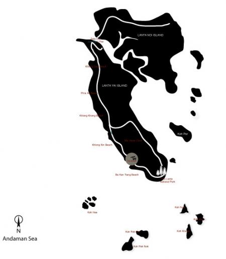
Koh Lanta (or Lanta Island or Koh Lanta Yai) which covers 472 square kilometers is an archipelago comprising more than 50 small islands. They are protected under the Marine National Park Authority, hence ensuring unspoiled nature and greenery. Altogether, there are 13 white sandy beaches lie along the west coast of the island. The east cost of Koh Lanta is flat with many local villages scattered along its coastline. The biggest town on the island is Lanta Old Town which is locally known as Ban Si Raya. In the past, Ban Si Raya was a commercial port for Chinese and Arabic trading boats sailing from china and the Middle East. It is a picturesque town featuring rows of old wooden Chinese shop-houses dating back a century. Nearby along the coastline, local fishermen dock their long-tail boats giving the whole scene a very serene and exotic Thai look. The best time of the year to visit Koh Lanta is between November and May.
Distance From :
- Krabi International Airport : 75 km.
- Lanta ferry pier (Ban Hua Hin) : 16 km.
- Saladan Night Market : 14 km.
- Klong Dao Beach : 13 km.
- Pra - Ae Beach : 11 km.
- Klong Tobe Beach : 8 km.
- Klong Nin Beach : 6 km.
- Ba Kantiang Beach : 400 m.
- Ao-Nui Beach : 2 km.
- Klong Chak Beach : 3 km.
- Mai Pai Beach : 5 km.
- Hin Gnam Beach : 6.5 km.
- Ta Nod Beach and Light House : 6.5 km.
- Lanta Island National Park : 6.5 km.
- Lanta Oldtown (Ban Si Raya) : 15 km.
- Thung Yee Peng Village : 13 km.
- Spring Water / Waterfall Walk : 4.5 km.
All rights reserved by thai-tour.com