This local
museum is at the Uthai Thani Provincial Non-formal Education
Centre on Si Uthai Road near the city hall. On display are
prehistoric human skeletons, clothes, regalia of city lords, and
a room of Thai house and wood models. Advance reservation is
necessary. For more information, please call 0 5651 1511.
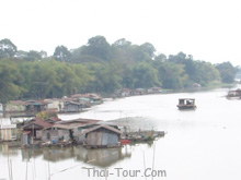
Rafts on Sakae
Krang River reflect the lifestyle of Uthai Thani people that has
always been linked with water. Water is used here to grow
pandanus and for raising fish in floating baskets, particularly
gourami, that has become a main occupation of the province and
which has made it famous. Tourists can take a boat to view the
life of people living on rafts on Sakae Krang River by boarding
at Lan Sakae Pier near Municipal 2 Fresh Market in Amphoe Mueang
or boarding at Lan Suphannika in front of the provincial hall on
Si Uthai Road. The route passes Wat Tha Sung and ends at Tambon
Tha Sung where Sakae Krang River and Chao Phraya River meets.
There are tour boats serving visitors. For more information,
please contact Pan House Travel at Tel: 0 2933 0577, 0 2538
0335, 0 2538 3705.
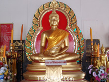
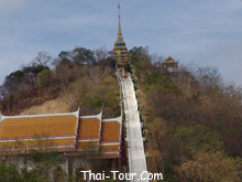
Wat Sankat
Rattana Khiri is at the foot of Khao Sakae Krang at the end of
Tha Chang Road in the municipality. Inside the main hall is
“Phra Phuttha Mongkhon Sai Sit” or “Luang Pho Mongkhon”, an
ancient bronze Buddha imae form the Sukhothai period in theMan
Wichai posture. It is 1.5 metres wide and was made in the reign
of King Lithai. In the open area of the temple is a stairway
ascending to the top of Khao Sakae Krang totaling 449 steps. At
the peak is a pavilion with a multi-tiered roof housing a
replica of Lord Buddha’s footprint and a large bronze bell built
in the reign of King Rama V. It is said that this is a sacred
bell that visitors to the province who does not ring the bell is
like on who never gets to see the province.
In addition,
in one corner of the temple is a pavilion housing a statue of
the father of King Rama I, the founder of the Chakri dynastr,
who was born in Ban Sakae Krang.
Getting There:
From the city, take Road No. 3220 and turn left into the
provincial staduum leading up the mountain. The distance is
around 4 kilometres.
Wat Tha Sung
(another name is Wat Chantharam) is at Mu 2, Tambon Nam Sum. It
is an old temple from the Ayutthaya period. It was formerly
called “Wat Chan” which is the name of an
abbot. Wat Chantharam later was abandoned until 1789 when the
monk Luang Pho Yai came here. Villagers asked him to become the
abbot of the temple and he renovated it. The first location of
the temple was on the bank of Sakae Krang River. The artifact of
the place is a pulpit built by Luang Pho Yai that is opposite
the temple. More buildings were later added by the monk Phra
Ratchaphrom Yan Nen (Luang Pho Ruesi Ling Dam). The new
convocation hall is beautiful with an ornately decorated
interior. The inner windows and doors have pictures of angels.
His Majesty the King presided over a ceremony to officially open
the building. Surronding the building is a traditional columned
wall. Images of Luang Pho Pan and Luang Pho Yai 3 times the
actual size is at the corner of the front wall. Furthermore, the
new site has a wide area as well as many pavilions with
accommodation for meditation. The main hall is open during
09.00-11.45 hrs. and 14.00-16.00 hrs. daily.
Getting There: From the city,
take Road No. 3265 to the ferry at Amphoe Manorom, about 6
kilometres away. Wat Than Sung is on both sides.
Wat
Thammakhosok or called “Wat Rong Kho” by
villagers was built in the early Rattanakosin period. It is on
Si Uthai Road, Tambon Uthai Mai in the municipality. It was used
to hold rites by Uthai Thani government officials to pledge
allegiance to the king as well as an execution site. The most
interesting places in the temple are the chapel and the main
Buddha image hall. The chapel is of the Rattanakosin period. A
tiled roof covers the building. The Buddha image here is highly
sacred. There are beautiful murals inside, the works of late
Ayutthaya artists. The main hall is a larger building that is
higher than the chapel. A pedestal inside has around 20 Buddha
images on it. The outer windowpanes have plaster drawings of the
epic Ramayana as frames. The doors have wooden floral patterns
painted in bright red.
The area. The ladder, once Sankat
Rattana Khiri up toward the top of the he Sakae Krang or use the
highway 3220 for a long distance 4 Km. Then turn
around the stadium District, then follow up to him from the top
of the top of the panoramic scenery can be his city Uthai Thani
has a large mondop to
establish the location of the footprints Bahts simulation, which
moved to the temple, Chan, a. In 1927. front is a bell of 2448,
the Permanent Secretary for
heart and the Uthai Thani join together to build a. In 1927.
2443 were considered a sacred bell who went to Uthai Thani, do
not depend on the stroke of the
bell, it is not going to the Uthai Thani
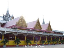
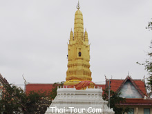
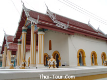
Wat Mani Sathit Kapittharam is
located on Sunthon Sathit Road, behind the health garden, at the
Clock Tower Circle. This temple was constructed in the
Rattanakosin period, and local people call it Wat Thung Kaeo.
Inside the temple, there is a large five-pinnacled prang, with a
width of 8 metres and a height
of 16 metres, which was built in 1909. The prang contains the
relics of Lord Buddha and the image of Luangpho Yaem who
constructed this temple. In the
area of the temple, there is a large holy water pool made of
bricks and a stone tablet with magic scripts of Luangpho Yaem
located in the middle of the pool.
Its water was once used to bathe the king in the coronation
ceremony of King Rama VI and King Rama VII.
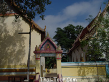
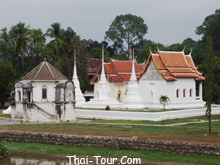
Wat
Ubosatharam was originally called “Wat Bot Manorom”
and is located in the municipality on the bank of Sakae Krang
River opposite Uthai Thani Fresh Market. It is surmised that it
was built in the early Rattanakosin period. Many historical
sites and artifacts are found inside, such as wall murals in the
convocation hall from the early Rattanakosin period that depict
the life of Lord Buddha from birth till death. They are of
exquisite craftsmanship. The murals inside the main hall are
also from the same period and depict Lord Buddha showing mercy
upon angels in heaven and others scenes. Moreover, there are 3
pagodas, each from different periods and of different styles.
Also of interest are the main hall, the convocation hall, the
prayer building, the octagonal multi-tiered rood, the Bot Nam
raft, the replica of Lord Buddha’s footprint from the time of
King Rama IV, a silver Buddha image weighing 30 kilograms, and
gifts from King Rama V to Luang Pho Chan Wat Bot when the king
visited Uthai Thani on 10 August 1906, like a monk’s bowl with a
pearl-inlaid lid, a stone monk’s bowl, a glazed bowl, a sack
used when the king visited Europe, a wide-month urn, a vase,
etc.
Bot Nam is in
front of Wat Ubosatharam on the bank of Sakae Krang River. It
was built to receive King Rama V when he visited northern
provinces in 1906. Originally a twin raft, it has an elongated
carved apex of the gable like normal temple main halls. It also
had a front part with a circular sign in Pali stating that the
king visited here in good faith. In 1976, the raft was renovated
and made into a single raft of floors so it is suitable for
monks to use. There is an area for worshippers to sit under a
four-sided roof. The sign has been moved to the middle of front
part of the roof. Today the raft is used by raft residents for
religious ceremonies such as weddings, ordinations, funeral, and
merit-making activities.
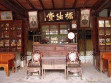
The museum hok saetung in the
city Uthai Thani home, the architecture. China is expected to be
age is not less than 100 years
in the area of the river Sakae Krang Uthai Thani Province
Chinese model first came to settle down here since the end of
the Ayutthaya mostly a
businessman who travel to the cargo ship with here is a market
because the boom in this area are mostly rice farming, loading
the cart, a farmer to come in
and sold to join as a Chinese traders and do business here and
the windmill, as well as the other is the Chinese live Chinese
often as well as an association, the
education system in the form of self-and try to keep the custom
of his own,
Located
Municipality, Uthai Rd. , Narong numbers, Uthai new
original name of the temple Panead abandoned later in the year
B.E. 2454 the beginning of the reign of integration with the 6
temple Wat temple and
changed the name new moon, but the villagers popular called the
"New temple "within a church mural shows a flower, and
strengthened (flowers of the city
of heaven) the church is similar to the ship raised by craftsmen
church in the arts China mix decorated with glazed tile pattern
Group vine
Located at Ban Tai
Thung Yai district, city Getting directions from the Thap Than
the Krok Phra district. The highway for a distance of 3005 km
will have
eight right-hand fork is 1.5 km to the gravel dam Wang protector
Dam is a small irrigation dam blocks the river or bask in the
Sakae Krang River. Muang
District, Uthai Thani Beautiful scenery around the reservoir dam
page.
In Thung Yai. Wang
Romklao to 300 meters is the place to find ancient remains bell
rock Base standing Buddha made of bronze stone bracelet stone
Buddha. Conditions city wall are still some remaining soil.
From the city to the
highway 3265 about 12 km turn to the ball nest on the bridge
canal rubber is about 4 km or may be rental from Takuan Yang
into
marsh for a long 5-6 km. bueng Tub swiftly, at the end of the
Huai B V, which has a length of around 8 km. quaggy wide around
300 meters is the source of
the fish are living in the marsh, abundant villagers rely on
water and catch fish in the swamps, bueng Park Thong found the
source of human history, a tool
of iron earthenware bead bracelets, glass, a tribe prosperous
because it is known for metal jewelry also found a bottle of
wine in western Ayutthaya.
is located adjacent
to school Nong Khayang Wittaya School Building up Prof.
important 1782 as the church building brick and cement deal by
craftsmen
and decorated with fine stuccowork pattern and the cup coated
with the entrance of the only chofa battlements around a
beautiful rock carvings on the
water-lilies base
in the house Uthai
Thani old is the location of the city, Thai Thani since those
days, Si Ayutthaya, which is still ruins, such as the temple Wat
Huamark rubber
and Wat kuti and its surrounding areas. has become a field to
the temple, remain in place until the present time, there is
temple Prang, a former. In 1927.
2081 later destroyed the top of the broken Burmese
reconstruction and repair. In 1927. old church, 2458, with a
small church door only in Ayutthaya at the
end of the stupa of fine stuccowork by craftsmen and skilled
church same temple, one is measured cities, which is still
remains an old church, Ayutthaya left,
and ancient pagoda small old church.
a cave that is in
Khao Wang Tong, Tambol Thung Po, is the height is about 325
meters away from Nong Chang about 20 kilometers, along with him
some a
rustle plain in the middle is a swamp large original wildlife
and drank some water, especially among a deer is especially
prevalent Cave springs on the foothill
inside the cave is a fountain and a rock with stalactites is
very beautiful.
This temple built in
the period. The old temple mural paintings of the reign of King
Rama 5 craftsmanship write about the Buddha such as at Camp
Phraya
daughter Mara to dance allure There are angels preaching,
please. There are escape ordination as a monk on the wall
assembly sitting Phanom hand That is
remarkable. A portrait dressed in a hat western wing. In
addition. Buddha Buddha statue there are models. Which is held
every year to worship Buddha.
A hill 372 meters
Phai green Away from the district about 9 km of cliffs,
beautiful And several caves. Stalagmite stalactite cave in the
sparkling beauty. Kwang Thong with him near his small brood, he
is a stone complex novel He is in the north. The large statue of
Lord Buddha is.
at Tambol Paikeaw
used route Sawang Arom-Lat Yao highway 3013 just before the end,
Uthai Thani Province there is a crossroad to bueng shed Chang
about another 20 kilometers. Rather remote communities in the
ancient city that is cooled and land surrounded by walls
discovered ancient pottery stone ruins of crushed a string of
beads tool steel, his yellow also dug found a stone inscription
font ancient 3 main at present there are a geography planting
large trees covered in the area around the city ditch shallow
In
Sub-district Poungsongnang, antimony, she is a big rocks that
parapet, and out of the rock him on the ground, large white
drained it within his boulders, there are many caves deep.
Huai Kha
Khaeng Wildlife Reserve consists of almost every kind of
forest found in Thailand, including mountain virgin forest,
dry virgin forest and pine forest. It has a total area of
about 2,780 square kilometres. The reserve covers the
sub-districts (Tambon) of Rabam and Pa O in Amphoe Lan Sak;
Khok Khwai and Kaen Makrut in Amphoe Ban Rai; Thong Lang in
Amphoe Huai Khot; and Mae Lamung of Amphoe Um Phang in Tak.
The reserve also connects with Thung Yai Naresuan in
Kanchanaburi. The unspoiled nature of the reserve makes it
an ideal home to various rare and endangered animals such as
wild buffalo, rhinoceros, wild elephant, red gaur, tapir,
leopard, wild bull, etc. In addition, it is the watershed of
rivers flowing to Srinakharin Dam. Due to these attributes,
Huai Kha Khaeng Wildlife Reserve was named by UNESCO as a
Natural World Heritage Site on 13 December 1991.
Huai Kha
Khaeng Wildlife Reserve has 3 points through which visitors
can tour the area:
1. The
area around the reserve headquarters is in Amphoe Lan Sak,
34 kilometres from the district. The area has an exhibition
building and the Sup Nakhasathian Memorial. The Khao Hin
Daeng walking nature trail is about 4 kilometres long. There
is also the Pong Thian viewpoint.
2. The
area around the Cyber Forest Protection Unit in Amphoe Huai
Khot is the site of the Huai Kha Khaeng Nature and wildlife
Study Centre to be set up by a private organization of Suep
Nakhasathian Foundation under the approval of the Royal
Forest Department. The centre consists of a study, a nature
trail that has direction and information signs, trailside
exhibitions, and viewpoints, among others.
3. The
area around Huai Mae Di Noi Forest Protection Unit in Amphoe
Ban Rai has a nature study walking trail arranged by the
Royal Forest Department for educational purposes.
All 3
points are open to tourists who wish to visit the reserve
and study nature. For more information, please contact the
Wildlife Conservation Division, Royal Forest Department,
Tel: 0 2561 4292-3 twenty days in advance or Huai Kha Khaeng
Wildlife Reserve, P.O. Box 4, Amphoe Lan Sak, Uthai Thani
61160.
Getting There: There are 2
routes to the reserve:
First route is to enter through the reserve headquarters
that is around 102 kilometres from the province. Take the
Uthai Thani-Nong Chang road (Highway No. 333) past Amphoe
Nong Chang to Highway No. 3438 (Nong Chang-Lan Sak) to Km.
53-54, then turn left onto a laterite road for about 14
kilometres.
Prehistoric colour drawings at Khao Pla Ra is another
interesting tourist attraction of Uthai Thani. Khao Pla Ra
is a mountain range with verdant jungles, no communities and
natural water sources. It is also the home of numerous wild
animals. It has truly lovely nature in the area around the
cave and cliff in the southwestern part of the mountain at
around 320 metres avove sea level. Colour cave drawings
stretch for around 9 metres. These prehistoric drawings are
of humans and animals in red and black.
They show
an agrarian society and are artistic expressions of people
in ancient times. The drawings give insight into their
lifestyle and homesteads. They are certainly invaluable as
artistic heritage of the country. A number of earthenware
pieces of three-legged pots and stone axes were also found
in the area.
Getting There: From the city,
take Road No. 333 past Amphoe Nong Chang, then take Road No.
3438 (Amphoe Nong Chang-Amphoe Lan Sak) for around 21.5
kilometres. You will see the Pla Ra Mountain range on the
left. Then turn left onto an asphalt road for about 7.5
kilometres and continue on foot around 2 kilometres up the
mountain to the peak to see the prehistoric drawings. The
total distance from the city is around 51.6 kilometres.
Hup Pa Tat
is a large valley with an area of about 48,000 square
metres. The mountain range surrounding the valley is a
limestone range. Part of it is Khao Huai Sok that connects
with Khao Pla Ra, about 1 kilometre away. The way up to the
cave is a margosa forest. Upon reaching the cave mouth you
will see a dark cave. After a walk of around 100 metres, you
will emerge from darkness and see the way down to the
valley. Looking around you will see a limestone mountain
surrounded by high cliffs. This enables sunlight to reach
the ground only at midday. Therefore, the valley has higher
humidity than other parts and this contributes to a wealth
of flora. The thick jungle features gigantic shrubs of the
genus Excoecaria that are similar to prehistoric trees.
Getting There: Use the same
route as Khao Pla Ra. It is 300 metres before the mountain.
Located in Lan Sak. Lan Sak District is behind
him cliff about 7.5 km away from the rhino is his Phraya rowing
about 8 km to his small son. High, about 376
meters inside his son is the location of the stalactite cave
with stalagmites. With a resident of the bat. Bureau and the
nearby hillside.
a cave in the mountains Ban Huai Sok,
Tambon Pa Oh, it is far from the province about 50 kilometers by
at the intersection Km.22 of the main road Nong Chang-lan sak in
village Bung Namtao Fang and village Huai to weep again 5 km
within can be divided into the hall many caves are. stalactites
beautifully in accordance with the nature and the vicinity is
the location of the temple Huai to grieve
The sub-district, Lan Sak district Lan Sak is a
forest that is the beginning of the rest of the only one in
Uthai Thani Province and the cooking for a forest park
for recreation, far from the province about 58 kilometers.
a mountain in the sub-district, Lan Sak is about
353 meters in front of him a gong is a wide shallow Cave like a
tunnel, understand that a man before history live because I
found stone tools and broken earthenware inside the cave of bats
inhabit in a number of very cold in the first time to see bats
fly out of Tin Pan Alley for a long time since the hours and if
it can be this year, high cliffs to be found in the cave on the
top Cave Thongchai Cave treasure Cave ducks and the wind cave
near the location of the ball, which he had another cave is
located in the middle is the land in the valley area of large,
which is the location of the temple and school lan sak science
if traveling from Nong Chang to Amphoe Lan Sak Tham Khao Chai
gong will be prior to Amphoe Lan Sak is about 5 km there is a
crossroad left school in the yard, science, about 200 meters, to
the cave he Khong Chai
The company of plywood Thailand Co. , Ltd. , with
a space of 2,890 rai in the forest, Huay a ballet, Tambon lan
sak amphoe lan sak away from the province 78 kilometers to go to
convert forest is to build a new a house Accommodation for the
most popular nature in the area of forest plantation planted
roses and varieties of plants
Ban Khok
Mo Weaving Village is a small village of Thai-Lao residents
whose ancestors migrated here in the Rattanakosin period.
Villagers take up weaving when the harvest ends. The fabrics
produced in the village are unique. They are made from Sin
Tin Chok Silk, Mat Mi silk and traditional-style fabrics
with floral patterns.
Getting There: From Amphoe
Thap Than, take Highway No. 3013 to Amphoe Sawang Arom for
approximately 11 kilometres. A 4-kilometre road leads to Ban
Khok Mo. The weaving group is next to Wat Khok Mo.
Wat Thap
Than was built in the Rattanakosin period around 1897. The
locals have shortened the full name to Wat Thap Than. It is
said that this area was where Thai troops caught up with
invading forces in the late Ayutthaya period. Hence, the
name of Thap Than. The monastery has a shady compund and a
small chapel and main hall in the traditional style. The
item of interest here is the lovely carved door depicting an
angel holding an arrow standing on a serpent and another of
an angel tending deer holding a pike on a lion. The
convocation hall has a main bronze Buddha image in the Man
Wichai posture 1.68 metres wide. The main hall houses a
replica of Lord Buddha’s footprint in bronze.
Getting There: Take Highway
No. 3221 (Amphoe Mueang-Amphoe Thap Than) for 19 kilometres.
The temple is located on the left about 1 kilometre before
the Thap Than district office.
Taluk in view A small mountain range about 750
meters long 253 meters high mountains look like the sort stacked
stone head Quite steep. The caves are
scattered around the cave, about 30 small and large cave roof
ladder cave cave cave basin outlet Buddha cave fish and cave bat
cave as a bat lives in caves.
You can climb a mountain to climb. Square area with shade his
face and lots of monkeys. The people are drawn to explore the
cave and watch the monkeys
always Pathawi he found stone tools and prehistoric human
skeleton.
Nong Ya Plong is located in the Ban Nong Ya Plong
travel from amphoe thap than to the road to rebuild in time-krok
phra distance about 2 kilometers to
find weekend,
buffalo, which is a market that is the area trading large
weekend of this is only on the day and he shaved only in each
time to Jacob, a water buffalo was
brought to sell the thousands.
This hill
Tribe centre has a house with a raised lower floor, a
thatched roof and bamboo walls. This is a replica of a Karen
house for tourists to see and there is also a room
displaying tools and utensils of Karens. There is
accommodation available and a cultural performance if
advance notice is given. Moreover, there are hill tribe
volunteers taking visitors to see nearby areas. For more
information, please contact Tel: 0 5652 0723, 0 5651 2026.
The Karen
village near here is Chao Wat Yang Daeng Village that
strictly adheres to old traditions. It leads a simple
lifestyle and has a peaceful atmosphere. The interesting
event of this village is the New Year Festival that is held
on the full moon night of April.
Getting There: From Amphoe
Ban Rai, take Highway No. 3011 (Ban Rai-Phu Bon) for about
17 kilometres.
Pha Rom
Yen Waterfall is in Ban Mai Rom Yen. The highlight of the
waterfall is its uniqueness of being a limestone waterfall
that falls from a cliff. It can be clearly seen from the
road nearby. This beautiful waterfall flows from a small
stream 4 levels up. It is about 100 metres high. The highest
level is a stream that falls down to a pool on the second
level. The highest level is the level that can be viewed
from the entrance. The beauty of this waterfall lies in the
fact that it falls down a high cliff, splashing into mist
down below. The nearby area is bright green with moss and
ferns. The surrounding nature provides cool shade for
visitors.
Getting There: From Amphoe
Ban Rai, take Highway No. 3011 (Ban Rai-Phu Bon) to the
entrance of Ban Mai Rom Yen, then turn right for around 2
kilometres. Then go on foot for 400 metres from the entrance
to the waterfall.
Wat Khao
Wong is a temple in a valley. It has a beautiful two-storey
Thai-style convocation hall. The area has been exquisitely
landscaped. The monastery is the 13th of 19 branches of Wat
Sangkhathan in Nonthaburi that are in places such as Chiang
Mai, Um Phang, the United Kingdom, and India. The monastery
was built in 1987 and has a total area of 320,000 square
metres. The surrounding area is mountain and forest.
The most
striking feature of Khao Wong Monastery is the 4-storey
Thai-style multi-purpose pavilion. Built almost entirely of
wood, the pavilion has a pond in front with many fish.
Around the pond is a garden of colourful flowers. The wood
used in the pavilion’s construction was donated by locals
and has been transformed into a work of architecture that
retains natural qualities. The monastery has a monthly
meditation class for those who are interested.
Getting There: Use the same
route as Phu Wai Cave. It is about 3 kilometres before
reaching the cave (there is a cooperative store selling
souvenirs and free accommodation for up to 200 persons).
This is a
small spring that sprouts up to the surface. The hot water
from underground converges to form a little stream that
flows down to Than Khok Khwai or Huai Khun Kaeo. The water
is clear and pungent with the aroma of sulphur. The water is
so hot that it can boil an egg in 5 minutes. The Royla
Irrigation Department has constructed Huai Khun Kaeo
Reservoir, flooding the stream and the spring itself.
However, and earth levee has been developed around the
spring and some landscaping has been done to create a good
rest area for visitors. The spring has an area of 4,000
square metres and consists of 3 springs. A mineral bath is
available for tourists and nearby is a 20-metre-high Buddha
image sitting high amidst the wonderful scenery of the area.
Getting There: From Amphoe
Ban Rai, take Highway No.3282 (Amphoe Ban Rai-Amphoe Huai
Khot) to Km. 41, then turn right to Ban Wang Yang Samo Thong
for another 24 kilometres. The total distance from the city
is 64 kilometres.
This
waterfall is in Huai Kha Khaeng Wildlife Reserve and
tourists are permitted to visit it. The waterfall is
situated amidst nature surrounded by the Huai Kha Khaeng
forest. The water comes from the western mountain of the
reserve, resulting in a medium-sized waterfall that drops
down several levels before splashing on the boulders below.
Beneath
the waterfall is the Cyber Forest Protection Unit. From
here, tourists must walk 5 kilometres to the waterfall.
Getting There: From Uthai
Thani, take the Uthai Thani-Nong Chang-Ban Rai road for
about 79 kilometres. From Amphoe Ban Rai, take Highway No.
3282 to Cyber village in Tambon Khok Khwai for another 30
kilometres. A sign points to the waterfall, then turn right
there for 7 kilometres.
Note: The route into the
waterfall is 7 kilometres long and is a rough laterite road.
It is unsuitable for low cars and sedans.
is located in the village Kut ja Roek
Sub-district, a stall a Eza Waterfall, Plaza, a waterfall
with flowing water throughout the year Waterfall, Plaza this
has happened in the creek, Plaza near the waterfall is the
forests is natural and area near Waterfall This is a wild
boar wild lives on the road to the highway 333 kilometers of
road Nong Chang-rai and separated into road Wang or
phalanger - the anchor of gold again about 18 kilometers to
the village Kut to เริก, on foot, about 3 kilometers , to
the waterfall, Plaza