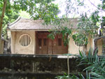
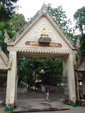
Arts and Culture Centre of Nakhon Si Thammarat Rajabhat Institute
Arts and Culture Centre of Nakhon Si Thammarat Rajabhat
Institute is 13 kilometres from the city on the Nakhon Si
Thammarat-Phrom Khiri Road (Highway No. 4016). It is the centre of
information on archaeological sites discovered in the province. On
display are ancient local tools and utensils from the establishment
of the community to the Srivijaya Empire. The centre also preserves
and revives local entertainment, as well as researches and collects
works on languages, literature and anthropology. The most important
artifacts here are the stone inscriptions found at Khao Chong Khoi
and artifacts from the ancient community at Wat Mok Lan. These vital
evidences relate when Nakhon Si Thammarat was built. The centre is
open daily during official hours.
Bang Pu
Bang Pu is
17 kilometres from the city and is at the Bang Pu intersection. This
is where quality pottery is made. Only bricks and flowerpots used to
be made here, but villagers from Ban Mok Lan have now set up stores
selling their handicrafts in this area. The products on sale have
been improved in variety and quality for greater marketing appeal.
Chedi Yak
Chedi Yak is the province’s second tallest pagoda, after
Phra Borom That pagoda. It is located near Nakhon Si Thammarat
Municipality in the abandoned Wat Chedi area. It is said that the pagoda
was built by Khotkhiri, a wealthy Mon, and his employees when they took
refuge in the city in 1003.
Chinese buildings at Wat
Pradu and Wat Chaeng
Chinese
buildings at Wat Pradu and Wat Chaeng is on Ratchadamnoen Road near
the provincial stadium. Built in the early Rattanakosin period, they
house the ashes of Phraya Nakhon and is believed to also have the
ashes of King Taksin the Great.
City wall
City wall
is alongside Ratchadamnoen Road. The wall was renovated in the early
Rattanakosin period and once more in 1990. The wall runs parallel
with the city moat from Chai Nua Gate or Chai Sak Gate to the east
for 100 metres.
Ho Phra Isuan
Ho Phra
Isuan is on Ratchadamnoen Road. It is a historical site of the
Brahman religion. On display is the Shiva Linga , the symbol of the
Brahman god Shiva. There are also several bronze images, such as the
Siwa Nattarat image, Phra Uma and Phra Phikkhanet. The bronze images
in this hall are replicas of the real images that are in Nakhon Si
Thammarat National Museum.
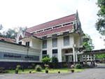
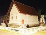
Nakhon Si Thammarat National Museum
Nakhon Si
Thammarat National Museum occupies the area of the former Wat Suan
Luang Tawan Ok. The museum was opened in 1974 and displays artifacts
found in the 4 southern provinces of Nakhon Si Thammarat,
Phatthalung, Surat Thani, and Chumphon. Of interest are the local
handicrafts display room. The national library building opened to
the public in 1976. There is a good collection of rare books and
important books sent by the National Library in Bangkok for locals
to study.
Phra Phutthasihing
Phra Phutthasihing is housed in the Phra Phuttha Sihing
hall near the Provincial Hall. This sacred image was believed to have
been ordered by the king of Lanka in 157 AD and was brought to Thailand
during the reign of King Ramkhamhaeng the Great. There are currently 3
similar images in Thailand. One is housed at the National Museum in
Bangkok, another at Wat Phra Sing in Chiang Mai and this image in Nakhon
Si Thammarat. The hall housing the image was originally the Buddha image
hall of the palace of Chao Phraya Nakhon (Noi). The hall is divided into
2 parts; the front portion houses Phra Phuttha Sihing, Phra Lak Ngoen
and Phra Lak Thong and the back portion houses the ashes of the
ancestors of the Na Nakhon family.
Phra Wihan Sung
Phra Wihan Sung, or Ho Phra Sung, is an important
historical site located just outside the ancient city wall to the north
in the area of Sanam Na Muang, on Ratchadamnoen Road. The site is so
called because of its high location on a hill, 2.10 metres above level
ground. There is no exact historical evidence but it is believed that
its architecture and wall murals are from the early Rattanakosin period.
The building houses plaster images with a thick, clay core. The images
are either from the 18th-19th century or from the late Ayutthaya period.
Residence of Ok Ya Sena Phimuk (Yamada Nagamasa)
Residence
of Ok Ya Sena Phimuk (Yamada Nagamasa) Yamada Nagamasa was a
Japanese volunteer soldier who lived in the Ayutthaya period during
the reign of King Songtham. For his many contributions to the
palace, he was rewarded by being bestowed the title of Ok Ya Sena
Phimuk and appointed lord of Nakhon Si Thammarat in 1629. Traces of
his home are still visible in the area of the Thai restaurant on
Nang Ngam Road (beside the provincial hall).
Shadow play house of Suchat Sapsin
Shadow play
house of Suchat Sapsin is at 10/18 Si Thammasok Road, Soi 3. Suchat
Sapsin received the 1996 Thailand Tourism Awards for the best
cultural and historical site. The house has a shadow play museum,
shadow play-making demonstrations and complete performances.
Visitors can appreciate this fascinating art by calling tel.
demonstrations and complete performances. Visitors can appreciate
this fascinating art by calling tel. 0 7534 6394.
Somdet Phra Sri Nakharin 84 Park
Somdet Phra
Sri Nakharin 84 Park is a large park with an area of over 490.23
acres. It is just behind the provincial stadium. Originally part of
Ratcharudi Park during the time of King Rama V, the park has an open
zoo, a bird park, a health park, and a lake which is home to
waterfowls that migrate here during January to March every year.
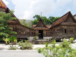
The Thai-style monks’ residence of Wat Wang Tawan Tok
The
Thai-style monks’ residence of Wat Wang Tawan Tok is on
Ratchadamnoen Road, in the area said to be opposite Wang Tawan Ok
(Eastern Palace), the retreat of Chao Chom Prang. Formerly a park,
Chao Phraya Nakhon (Noi) donated Wang Tawan Ok and the park opposite
it to a temple, now known as Wat Wang Tawan Tok(Western Palace
Temple). In 1888, Phra Khru Kachat (Yong) and his disciples built a
group of houses for monks. The 3 houses have a pointed roof
connected to the other and there are exquisite Nakhon Si Thammarat
designs on the walls, doors, windows, and vents. The Siam Architects
Society named these houses the best conservation effort in the area
of historical sites and temples in 1992.
Wat Chai Na Meditation Centre
Wat Chai Na Meditation Centre is on Phatthanakan Thung
Prang Road. Meditation courses are held for Thais and foreigners. The
famous monk Phutthathat Bhikkhu established the centre as a branch of
his monastery in Surat Thani. The centre is peaceful with an abundance
of shady trees.
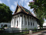
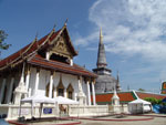
Wat Phra Mahathat Woramahawihan
Wat
Phra Mahathat Woramahawihan is located on Ratchadamnoen Road in
Tambon Nai Mueang. This is a royal temple of the first class.
Formerly named Wat Phra Borom That, this is one of the most
important historical sites in southern Thailand and in all of
Thailand. According to the legend of Phra Borom That Nakhon Si
Thammarat, Prince Thanakuman and Queen Hem Chala brought Buddha
relics to Hat Sai Kaeo and built a small pagoda to mark the
location. Later on, King Si-Thamma Sokarat established the city of
Nakhon Si Thammarat and built a new pagoda. The present pagoda has a
distinctive Sri Lankan style, measuring 55.78 metres high (measured
by the Fine Arts Department during the renovation of the gold top in
1995). The height from the lotus base to the gold top is 6.80
metres. The top is entirely covered by pure gold. Inside the temple
are many buildings of importance, especially the royal building
which has beautiful architecture from the Ayutthaya period and the
Sam Chom building where the Buddha image attired in royal wardrobe,
Phra Si Thamma Sokarat , is housed. There are also the Phra Maha
Phinetkrom (the equestrian image) building and the Thap Kaset
building, while the Khian and Pho Lanka buildings are used to
display artifacts that were donated to the temple by Buddhists.
Pak Phanang
Ban Rang Nok
Ban Rang
Nok is famous for the numerous swallow bird nests located in the
town. Several houses and buildings have been closed because of the
immense number of swallows inhabiting them. These birds make the
houses their homes, though they predominantly inhabit caves and
mountains. However, the nests are not easily accessible as they are
in private properties.
Museum Honouring the King for the Development of Pak Phanang Basin
Museum
Honouring the King for the Development of Pak Phanang Basin is a
museum conceived by the Project to Develop Pak Phanang Basin by His
Majesty the King that covers Nakhon Si Thammarat, Phatthalung and
Songkhla. The museum is in the project itself and consists of His
Majesty’s office, a meeting room and an exhibition room on Pak
Phanang’s history. For more information, contact tel. 0-7551-7933,
0-7551-7534.
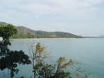
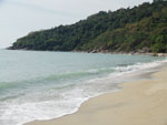
Pak Phanang Coast and Talumphuk Cape
Pak Phanang
Coast and Talumphuk Cape are the sites of a severe storm in Nakhon
Si Thammarat in 1962. The coast of Pak Phanang is a long beach with
the Talumphuk cape to the north jutting out into the Gulf of
Thailand like a crescent moon. Some villages are located on the part
that is connected to Nakhon Si Thammarat Bay, while the gulf coast
has a beautiful, pine-lined beach. To get to both places, take
Highway No. 4013 (Nakhon Si Thammarat-Pak Phanang), and then 16
kilometres on a road to Pak Phanang. Both sides of the road are
lined with shrimp farms and mangrove forests.
Wat Nantharam
Wat
Nantharam used to be called Wat Tai and currently houses Luang Pho
Phut, a red sandstone Buddha image from the Ayutthaya period. Pak
Phanang people worship this sacred image. In addition, the temple
houses a giant phallic symbol found at Khao Kha archaeological site
that is believed to be around 1,200 years old, from the 7th-9th
century. The symbol is carved from limestone and is the most
complete in southern Thailand. The temple is at Chai Nam Road, on
the western side of Pak Phanang.
Ron Phibun
Fan Making Village
Fan Making
Village is on Highway No. 403, 40 kilometres from Amphoe Muang to
Amphoe Ron Phibun. The villagers here use their spare time to make
Kapho fans for sale nationwide. This popular, local handicraft is
affordable and very useful.
Chulabhorn
Khao Chong Khoi Stone Inscription
Khao Chong
Khoi Stone Inscription is at Ban Khok Sathon, Moo 9, Tambon Thung
Pho, Amphoe Chulaphon. This is the oldest Sanskrit stone inscription
found in southern Thailand and dates from the 6th-7th century. It
tells the story of people asking for shelter from Shiva and jungle
spirits. It ends with the saying “If a
good person resides in a village, then that community shall find
happiness and prosperity”.
Tha Sala
Ban Nai Thung Handicrafts
Ban Nai
Thung Handicrafts can be found 24 kilometres from the city. Ban Nai
Thung is a Muslim Thai village near the sea. Aside from fishing,
villagers use their spare time to make colored cloth kites in the
shape of birds, as well as birdcages, for sale on both sides of the
road. This village is well worth a visit for some quality products.
Khao Nan National Park
Khao Nan
National Park is 30 kilometres from Amphoe Tha Sala. The park covers
areas in Amphoe Tha Sala, Amphoe Sichon and King Amphoe Nop Phitam.
In addition, the park has areas in Pa Khao Nan National Forest
Reserve and Pa Krung Ching National Forest Reserve. The total area
of the park is 436 square kilometres. The main topography is a high
mountain range extending from Khao Luang National Park. The park
itself is a watershed of many waterways. From the city, travel by
Highway No. 401 across Khlong Klai, and past Ban Sa Kaeo in Amphoe
Tha Sala. Upon reaching the 110-km marker, turn left into Ban Pak
Chao and drive 15 kilometres to the park office.
Pottery Village
Pottery
Village is just 50 metres from Wat Mokhlan. The village still
adheres to the old technique of making pottery by hand. The pots
made here are large, thick, and have little design.
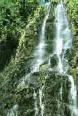
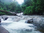
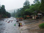
Sunantha Waterfall
The park’s
main attraction is the small but lovely Sunantha Waterfall. Water
drops down a steep cliff to the pool below before flowing into
Khlong Klai, the main waterway of Tha Sala. Rafting can be done in
the canal during the rainy season, when the water level is high.
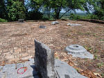
Wat Mokhlan Archaeological Site
Wat Mokhlan Archaeological Site is in Tambon Don Kha and
is 10 kilometres from the district office. To get there, take Highway
No. 401 to Ban Na Thap, turn left onto Highway No. 4022 and drive for 6
kilometres. Originally a religious place for Brahmans of the Sawai Nikai
sect, the artifacts found here date from the 7th-9th century. Items that
can be seen here include traces of stone pillars, carvings around
doorways, religious stones, an ancient pond, and statue bases. The Fine
Arts Department declared this area an archaeological site in 1975.
Sichon
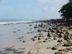
Hat Hin Ngam
Hat Hin Ngam has a unique characteristic in that it is
littered with round rocks of various striking colors, hence its name.
There are no services here.
Hat Kho Khao (Hat Piti)
Hat Kho Khao (Hat Piti) is a popular beach that connects
to Hin Ngam beach. There are accommodation and restaurant facilities for
tourists.
To get to these 3 beaches,
take Highway No. 401 from Amphoe Mueang for 70 kilometres to Amphoe
Sichon. Turn right to Ban Pak Nam and go for 3 kilometres to Sichon
beach (Hua Hin Sichon). From there, it is 1.5 kilometres to Hin Ngam
and Kho Khao (Piti) beaches. Piti beach is 2 kilometres from Hin
Ngam beach.
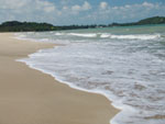
Hat Sichon, or Hua Hin Sichon
Hat Sichon,
or Hua Hin Sichon as known to locals, is a well-known destination of
the district. Rocks line the beach all the way to a curved sandy
stretch where people can swim. There is accommodation and
restaurants for tourists.
Khao Kha Archaeological Site
Khao Kha
Archaeological Site in Tambon Sao Phao. To get there, take Highway
No. 401 from Si Phibun intersection to the 99-km marker, and turn
left onto Chinda Pracha Sawan Road for 7 kilometres. Khao Kha was a
sacred religious place of the Sawai Nikai Brahman sect who worshiped
Shiva as their highest god. Khao Kha was regarded as being similar
to the mythical Khao Phra Sumen, a centre of worship, that was
surrounded by smaller, secondary historical sites. Many artifacts
that were used in rites have been found here, including phallic
symbols, holy water pipes, ruins, and an ancient pond. The site
dates from the 8th-9th century. The Fine Arts Department completed
its renovation in 1997.
Si Khit Waterfall
Si Khit
Waterfall is in Moo 2, Tambon Si Khit. It is 15 kilometres west of
Sichon beach on Highway No. 4105. This small waterfall originates in
the mountains to the west and flows down several levels amidst
pristine natural surroundings.
Khanom
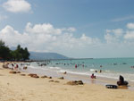
Ao Khanom
Ao Khanom is the largest bay in Khanom District.
It is 1.5 kilometres from the district office and can be reached by
taking Highway No. 4014, which separates from Highway No. 401, for
17 kilometres, then 1 kilometre past Khanom Public Health Area
Market, then turn right and drive along Khanom beach. Khanom beach
is a long beach that connects to other beaches, as follows:
Hat Nai Phlao
is Khanom’s largest beach and the most popular tourist attraction. The
beach curves along a mountain range. The overall scenery is one that
features perfect nature, including a clean, white beach conducive to
a day in the sun. Accommodation and restaurant facilities are
available.
Hat Na Dan
is a long, palm-fringed white beach. From this quiet beach, one can
see the beautiful aquamarine water of the Gulf of Thailand.
Hat Nai Praet
is a beautiful, long curved beach. This beach is between Hat Na Dan
and Hat Nai Phlao and is rocky in some areas. This popular beach’s
natural ambience has been impressing visitors for years.
Ao Thong Yi
Ao Thong Yi is a beach that is very suitable for camping
because of its complete natural surroundings. Ao Thong Yi is encompassed
by Khao Phlao and Khao Klang, making it peaceful and removed from the
outside world. Accommodation can be obtained by contacting the owner of
the property. To get there, take a laterite road from Hat Nai Phlao near
Khanap Nam Resort. The distance to there is 2.5 kilometres.
Phrom Khiri
Ban Plai Uan
Ban Plai
Uan in Moo 5, Tambon Phrom Lok is at the foot of Khao Luang near
Phrom Lok waterfall. Most residents cultivate fruit orchards. The
Nature Conservation for Jungle Trekking Club is located here. One
can trek 5 kilometres from the village to Phiman Mek waterfall,
which is 1,505 metres above sea level. Along the way are many
interesting flora, fauna, caves, streams, and the gigantic red palm
of the genus Caryota, which is a plant with very unique features.
For more information, please contact the Ban Plai Uan Nature
Conservation Club, tel. 0-7533-8633
Muang Nakhon Reception House
Mueang Nakhon Reception House was built to receive His
Majesty the King (Rama IX) and H.R.H. Crown Princess Maha Chakri when
they visited the city. It is located in an old fruit orchard of the
Thongsamak family who built the house for the royal family on behalf of
the city’s people. The area is covered with various kinds of native
fruit trees and has been decorated with beautiful and shady plants. The
house is open to the public daily, except Wednesdays and when the royal
family is there.
Namtok Ai Khiao, or Nai Khiao Waterfall
Namtok Ai
Khiao, or Nai Khiao Waterfall, is in Tambon Thon Hong. It is 30
kilometres from the city on Highway No. 4016, on the same route as
Phrom Lok waterfall. At the 26-km marker, turn left onto the road
and continue for another 3 kilometres. Originating from Khao Luang,
this waterfall has 9 levels, which are Nan Chong Sai, Nan Bang Bai,
Nan Mai Phai, Nan Sua Phan, Nan Buppha Sawan, Nan Hin Kong, Nan Hua
Chang, Nan Sai Kwat Lan, and Nan Fa Faet. The surrounding area is
still a dense jungle. Both sides of the falls are covered with betel
gardens. The locals call the betel Phlu Pak Sai because of its hot
flavor and sweet scent. The view of Khao Luang is best viewed from
here.
Namtok Phrom Lok
Namtok
Phrom Lok is in Tambon Phrom Lok. It can be reached via Highway No.
4016 (Nakhon Si Thammarat-Phrom Khiri) to the 20-km marker, then
turn left onto Highway No. 4132 for 5 kilometres. This is a large
waterfall with wide and lovely rock platforms. It originates from
the Nakhon Si Thammarat mountain range and flows down 4 levels,
which are Nan Bo Nam Won, Nan Wang Mai Pak, Nan Wang Hua Bua, and
Nan Wang Ai Le. The water flows past many kinds of flora before
going to Khlong Tha Phae and ending in the Gulf of Thailand in
Tambon Pak Phun.
Wat Khao Khun Phanom and the Khao Khun Phanom Scientific Study
Centre
Wat Khao
Khun Phanom and the Khao Khun Phanom Scientific Study Centre is in
Moo 3, Tambon Ban Ko. From the city, use Highway No. 4016 to the
21-km marker, past Phrom Lok market, then take a right-hand road for
2.5 kilometres. Wat Khao Khun Phanom is a temple of historical and
archaeological importance. The temple has a cave lined with a brick
wall and marked with heart-shaped stones marking the limits of the
temple similar to those along the city wall. The front wall has
plaster designs decorated with Chinese porcelain. In the cave are
about 30 bronze Buddha images and a bronze Buddha’s footprint.
Several smaller connecting caves branch out from the main cave like
an elaborate fortress maze. Many believe this is where King Taksin
the Great used to stay. Others say it was the rest stop of Princess
Kesini, daughter of Chao Nara Suriyawong, the lord of Nakhon Si
Thammarat during 1769-1776.
On the way up Khao Khun
Phanom is the Khao Khun Phanom Scientific Study Centre that provides
knowledge on science, technology, the environment, and eco-tourism
to the public. The Khao Khun Phanom community is a cultural
community. There is a training camp activity and a grouping called
the Tourism to Study Fruit Orchards by Bicycle Club. For more
information, call tel. 0-75 34-5154.
Lan Saka
Ban
Khiri Wong
Ban Khiri
Wong is an ancient community that settled at the foot of Khao Luang
in Tambon Kamlon, near a path that goes up the mountain. This
peaceful village is like one big, happy family. The main occupation
is growing fruits, such as mangosteen, rambutan, durian, and Sato.
The village was faced with catastrophe on November 21, 1988 when a
flash flood swept away some 100 houses. The local monastery and
villagers still maintain the damaged convocation hall and houses as
monuments to those who perished. Ban Khiri Wong is considered a
prototype of eco-tourism management and the place won the 1998
Thailand Tourism Award in the city and community category.
The village is a good
example of local people living in co-existence with nature.
Residents have developed tourism services to be a new business for
the area through the Eco-tourism Club, a central organization that
delegates responsibilities to groups in the community to create
cooperation. The services include trekking tours, porters and
homestay programs. Tourists can appreciate the way of life here all
year round, with the most attractive time during July to September
when fruits are on sale. Trekking up Khao Luang must start at Ban
Khiri Wong. One can get to the village by taking a mini-bus from
Talat Yao. Buses depart from 7 a.m.-4 p.m. The fare is 17 baht.
Alternatively, one can drive on the Amphoe Mueang-Lan Saka route for
26 kilometres. The sign pointing to the village is at the 20-km
marker on the right. For more information, contact the Tambon Kamlon
Administration Office at tel. 0-7530-9010.
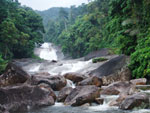
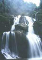
Karom waterfall
Karom
waterfall is 9 kilometres from the city. Take Highway No. 4016, then
turn left onto Highway No. 4015 for 20 kilometres, and the entrance
to the waterfall will be on the right. The waterfall originated in
the Nakhon Si Thammarat mountain range and cascades down 19 levels,
with names like Nan Phung, Nan Nam Ruang, Nan Dat Fa, and Nan Soi
Dao (the highest level at 1,300-1,400 metres). Kings and royal
family members have visited this waterfall, as evidenced by the
initials of King Rama V and King Rama VI carved there.
Khao Luang National Park
Khao Luang
National Park covers Amphoe Muang, Amphoe Phipun, Amphoe Phrom
Khiri, Amphoe Lan Saka, Amphoe Chawang, King Amphoe Chang Klang, and
King Amphoe Nop Phitam. Having a land area of 597 square kilometres,
it was declared a national park on December 18, 1974. The park has a
winding mountain range, with the Khao Luang peak the highest of the
peaks in southern Thailand at 1,835 metres above sea level. It is
the watershed of more than 15 streams and rivers. The park’s
rainforest is home to a multitude of tropical flora and fauna. There
is a route that takes visitors around the park to see unspoiled
natural scenery, the variety of wildlife and rare animal and plant
species, some of which can only be found in the park. The beauty and
completeness of the park, its fascinating nature, the park’s efforts
to encourage the local community and tourists to be aware of the
importance of nature, and its excellent tourist service system have
all combined to help the park win the 1998 Thailand Tourism Award in
the natural destination category. For more information and
accommodation bookings, please contact Khao Luang National Park at
Karom waterfall, Tambon Khao Kaeo, P.O. Box 51, Amphoe Muang, Nakhon
Si Thammarat 80000, tel. 0- 7530-9047.
Khao Luang peak
Khao Luang
peak features a trekking activity to enjoy nature on the Ban Khiri
Wong-Khao Luang peak route. The normal trekking time is 2 nights and
3 days. Permission can be obtained from Khao Luang National Park and
Tambon Kamlon Administration Office, who facilitates the trek and
provide coordinating activities with the communities who provide the
eco-tourism services. Treks are normally organized for groups of 10.
The best time for this is from January to June.
Phipun
Namtok Ranae
Namtok
Ranae is in Moo 6, Tambon Phipun. To get there from Nakhon Si
Thammarat city, take the Nakhon-Lan Saka, Chandi Road (Highway No.
4015) for 55 kilometres (the same route as the one to Suan Ai and
Suan Khan waterfalls). Then continue on the Chandi-Phipun bus for 18
kilometres. Approximately 1 kilometre before you reach Phipun
district office, there is a sign on the right pointing to the
waterfall. Take that road for 10 kilometres. This beautiful,
ten-level waterfall is well worth a visit.
Thung Song
Kuan Im Goddess Image
Kuan Im
Goddess Image is a large white plaster image of the popular Chinese
goddess. Standing at a height of 19 metres, it is easily visible
from afar. She is posed in the benevolence gesture, with the left
hand holding a vase containing magic water while the right holds a
Lew tree branch. The image stands on a large lotus beside a boy and
a girl statue. A big dragon is paying homage to the image. The image
is situated in the middle of a large pond surrounded by fountains.
You can find this spectacular piece of art at Sam Po Kong Foundation
(Luang Pho To), Moo Ban Phatthana Road, Tambon Pak Phraek,
approximately 1 kilometre from Thung Song market.
Namtok Yong National Park
Namtok Yong
National Park, or locally known as Yong Sai Yai waterfall, has a
total area of 49,403.25 acres. Covering the areas in Thung Song, Na
Bon, and Chawang, it was proclaimed a national park on December 10,
1987. The park’s pristine nature includes the Yong Waterfall where
streams converge into one giant rope-like waterfall dropping from a
high cliff to the large pool below. There is also the Plieu
Waterfall at Pa Praek, a smaller waterfall measuring 25 metres high.
An ascent from Ban Nam Ron to the top takes about 1 hour. To get to
the park, take the Nakhon Si Thammarat-Thung Song Road for 50
kilometres, turn right, and drive for 3 kilometres to the park.
Tents are available for tourists. For more details, please contact
the park at Moo 2, Tambon Tham Yai.
Tham Talot
Tham Talot
is 500 metres from Thung Song district office. This is a small cave
in Chai Chumphon Mountain. The cave can be traversed from one exit
to the other, hence, its name of Talot or Lot (cut-through) cave.
Inside is a huge reclining Buddha image stretching the length of the
cave. This sacred image is decorated with murals of Lord Buddha’s
life drawn by Mr. Naep Thichinnaphong, a famous artist of Nakhon Si
Thammarat. The area around the cave has been developed into a park
with a store selling food and drinks.
Tham Phannara
Wat Tham Thong Phannara
Wat Tham
Thong Phannara is in Moo 9, Tambon Tham Phannara, about 2 kilometres
from the Asia Highway (Highway No. 41) at the 192-193 km. marker,
and about 1 kilometre from the district office. Legend has it that
two nuns, named Pring and Prang, came by sea with many followers and
valuable belongings for use in the building of a pagoda to entomb
Lord Buddha’s relics. However, when they arrived at the port (Ban
Pak Ra now), they found that the pagoda had already been completed,
so they chose another suitable site to build, which was Thong cave.
They then built a
reclining Buddha image in the cave. When the nuns died, their
descendents placed their bones in the 2 Buddha images that they
built. Since then, it became a tradition that on the first night
with a full moon of the 11th lunar month (October), people would pay
homage to the reclining image and the images representing the nuns
called Phra Pring and Phra Prang. This Khun Tham ceremony is
attended by a great number of worshippers who bring with them
desserts for offerings and who come to tour the caves that consist
of both dark and brightly lit caves.
Chang Klang
Namtok Suan Ai
Namtok Suan
Ai is in Moo 5, Tambon Khlong La-ai, Amphoe Chawang. From Nakhon Si
Thammarat, take the Nakhon-Lan Saka-Chandi route (Highway No. 4015)
for 55 kilometres. Of its 5 levels, visitors can enjoy 3 which are
Nan Chong Som Lot, Nan Ton Riang and Nan Laoka.
Namtok Suan Khan
Namtok Suan
Khan is in Moo 3, Tambon Suan Khan. It can be reached by taking the
Nakhon-Lan Saka-Chandi route (Highway No. 4015) for 55 kilometres
and connecting to the Chandi-Phipun bus for 4 kilometres. The very
beautiful nature here is conducive for trekking and exploring the
flora of the area. Three levels of the waterfall can be accessed.
Namtok Tha Phae
Namtok Tha
Phae is in Moo 14, Tambon Chang Klang. The waterfall can be reached
by taking the Nakhon-Chandi-Chawang-Ban Song route (Highway No.
4015) for 36 kilometres, then turn right at the sign for 2 more
kilometres. This beautiful, ten-level waterfall has 3 levels which
are accessible to the public; Nan Phae Noi, Nan Nang Khruan and Nan
Toei.
Nopphitam
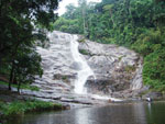
Namtok Krung Ching
Namtok
Krung Ching is a beautiful and important waterfall of Khao Luang
National Park. Located in Tambon Krung Ching, the waterfall derived
its name from Ton Ching, a kind of palm prevalent in the area. The
waterfall has many levels, each with a different name, such as Nan
Mut Phae, Nan Fon Saen Ha, Nan Plew, Nan Chon, Nan Chone, Nan Ton
To, and Nan Wang Rua Bin. The most breathtaking level is Nan Fon
Saen Ha where water drops off a sheer cliff 100 metres high,
splashing down creating a mist covering the area like rain unlike
other falls. The waterfall is under the jurisdiction of the Khao
Luang National Park Protection Unit. A 3.8 km. long road leads
directly to Nan Fon Saen Ha. The area has a training centre,
accommodation and a campground.
To get to the falls, take the Nakhon Si Thammarat-Phrom Khiri Road
(Highway No. 4016). Upon reaching Na Reng intersection, turn left to
King Amphoe Nop Phitam and turn right onto Highway No. 4186. The
total distance is 70 kilometres.
Namtok Yot Lueang or Namtok Muang Mai
Namtok Yot
Lueang or Namtok Muang Mai, is to the south of Krung Ching waterfall
in Moo 6, Tambon Na Reng. This medium-sized waterfall has 4 levels,
which are Nan Toei, Nan Kradot, Nan Ya Kha, and Nan Plio. Swimming
can be enjoyed here amidst the coolness of the jungle. To get to the
waterfall, take the Nakhon Si Thammarat-Phrom Khiri route (Highway
No. 4016) for 40 kilometres.
Rafting on Khlong Klai
Rafting on
Khlong Klai (can be done on rubber boats provided by Krung Ching
Administration Office in Moo 3, Tambon Krung Ching, near Krung Ching
waterfall. There are 2 rafting routes, one is the 2.5 km. Pak Khlong
Phitam-Lan Hin Dan route that takes 1 hour and the other is the 6
km. Pak Khlong Phitam-Ban Thung Nai route, requiring 3 hours for
completion. The fee is 250-350 baht/person. For more information,
contact tel. 0-7530-9004 and 0-1677-3112.
Tham Hong
Tham Hong
is a medium-sized cave with a stream running through its centre
before going subterranean to another stream outside. Stalactites and
stalagmites of strange shapes abound in the cave. The most
distinctive characteristic of the cave is a waterfall that drops
down 3 levels. Visitors in the cave must wade through water before
emerging from the exit 300 metres away. The cave is under the
jurisdiction of the Khao Nanthi National Park Protection Unit
(Khlong Lamphaen). The cave is situated just before Krung Ching
waterfall.
Na Bon
Namtok Khlong Chang
Namtok
Khlong Chang and Trekking on Khao Men are must things to see and do
in this district. The waterfall has 7 tiers and is one of southern
Thailand’s most beautiful cascades. The waterfall originates in Khao
Men, which is the third highest mountain in southern Thailand after
Khao Luang and Khao Nan (Nakhon Si Thammarat mountain range). The
waterfall area is still a verdant forest. Trekking up the
1,235-metre-high Khao Men is recommended as a cool mist covers it
the year round and it possesses more than 300 exotic plant species.
To get there, take the Nakhon Si Thammarat-Thung Song road to Khuan
Mai Daeng intersection. Turn right towards Na Bon on NS2001 Road for
about 11 kilometres to the waterfall. The recommended time for
trekking is 2 days and 1 night and the most suitable period is
December to April. For more information, contact the 17th Volunteer
Territorial Defence Company of Na Bon at tel. 0-7549-1244.