|
Conquer the Summits
The Emerald of the Northeastern Region
Loei conjures up images of fertile forest, chilly weather, and
lingering fog. Foe many, no forests and mountains are more
tempting than Phu Kradueng National Park, Phu Ruea National
Park, and Phu Luang Wildlife Sanctuary. These big names have
become jewels of the region, and give Loei its proper its Proper
title of “the city of sea of mountains, the coldest spot in
Thailand”.
Phu Kradueng National Park
|
Phu Kradueng is unquestionably one
of the most popular tourist spots in Thailand, thanks to its
unspoiled environment, diverse ecological systems and
geographical features, incorporating grasslands, coniferous
woodlands, evergreen forests, waterfalls and viewpoints. In the
winter, especially during New Year holidays, Phu Kradueng has
become crowded with the thousands of tourists.
Phu Kradueng is a flat-topped
sandstone mountain. Its heart-shaped flat plateau on the top
covers about 60 square kilometers at an the altitude of
400-1,200 meters above sea level.
|
|
Tourists are required to climb an uphill route of 9 kilometers
to its flat plateau; hence physical fitness is indispensable.
Trekking on Phu Kradueng
The rather steep climb uphill covers about 5 kilometers.
Exhausted trekkers can buy refreshment at various rest areas,
call “sam”, along the way.
1.
Pha Nok Aen
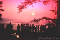
Pha Nok Aen is the most convenient viewpoint to admire the first
light of day. Many tourists are captivated by the sea of fog
lingering over the valley to go to Pha Nok Aen very early in the
morning with the help of a flashlight to avoid disappointment.
Along the sunset cliff
Sunset can be admired along the 9 kilometers cliff, from Pha Mak
Duk to Pah Lom Sak.
2. Pha Mak Duk
About 2.5 kilometers from the accommodation, Pha Mak Duk is a
large rocky terrain overlooking Phu Pha Chit, the highest peak
in Nam Nao National Park. In the summer, Rhondodenron
Iudwigianum adorn the route along this sunset cliff. Pha Cham
Sin is 600 meters away from Pha Mak Duk, followed by Pha Na Noi
(700 meters further away),
Pha Yiap Mek
(2 kilometers),
Pha Daeng
(1.5 kilometers)
and Pha Lom Sak
(2.5 kilometers.)
3. Pha Lom Sak
 The
Most popular sunset viewpoint and the park’s symbol, Pha Lom Sak
has a large rock protruding over the cliff, with a large conifer
nearby. Flashlights and food are indispensable for the 3 hours
walk back to the accommodation. This route passes large
grassland and scattering pine forests. The
Most popular sunset viewpoint and the park’s symbol, Pha Lom Sak
has a large rock protruding over the cliff, with a large conifer
nearby. Flashlights and food are indispensable for the 3 hours
walk back to the accommodation. This route passes large
grassland and scattering pine forests.
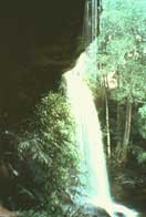
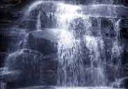
Waterfall
1.
Wang Kwang Waterfall
About 1 kilometer from the accommodation, the 3-leveld Wang
Kwang Waterfall is about 7 meters high.
2.
Phen Phop Mai Waterfall
About 1 kilometer from Wang Kwang Waterfall, al large rock broke
to form a 20 meters high cliff, from which water falls below.
3.
Phon Phop Waterfall
This 8-leveld, 30 meters high waterfall is hidden by thick
adorns this waterfall with its flamboyant colors.
4.
Phen Phop Waterfall
This 3-leveled, 10 meters high waterfall is less than 1
kilometer further from Phon Phop Waterfall. The route along the
creek from Phen Phop to Tham Yai Waterfall passes through very
fertile evergreen forest. Apart from scattering maples, various
varieties of mushrooms, ferns, palms and rattan can be found
along the way.
5.
Tham Yai Waterfall
The rugged gray stone
cliff of about 10 meters is naturally embellished with
maple foliage during winter.
|
|
6.
Than Sawan Waterfall
This small waterfall may not be competitive in terms of
grandeur, but is much so in terms of relaxing atmosphere.
7.
Tham So Nuea Waterfall
Mother Nature forced broken a solid rock to create a cliff. The
resulting Tham So Nuea Waterfall is distinctive as people can
walk along the curvy pathway under the protruding rocky to
admire the waterfall from behind. Large rock terrain in the
upper part of the waterfall provides perfect spot for
relaxation.
8.
Tham So Tai Waterfall
This smaller waterfall is on the same creek as Tham So nuea.
9.
Sa Anodat
An alternative route of waterfall may leads directly to a
natural reservoir called Sa Anodat. This route cuts through lush
coniferous forest. Near the pond is rock terrain covered with
lichen and many flowering dwarf plants.
Visitors can stay in row houses or camps. Advance reservation is
required at the Forestry Department. Khet Chatuchak, Bangkok
10900. The Park is close during June-September every year to
allow the nature to recuperate.
-----------------------------------------------------------------
Phu Luang Wildlife Sanctuary
Phu Luang, literally meaning “big mountain”, covers an area of
about 848 square kilometers in the districts of Wang Saphung,
Phu Ruea, Dan Sai and Phu Luang. The plateau atop Phu Luang
covers about 140 square kilometers. Phu Luang consists of many
mountains with the altitude ranging 400 – 1,550 meters above sea
level, the highest peak being the 1571 meters high names Phu
Khwang.
The 3 seasons on Phu Luang have much lower temperatures than
their counterparts at the ground level. Summer during
February-April has an average temperature of about 20 – 24
degrees Celsius. The rainy season during May – October has
similar temperatures drops to an average of 0 – 16 degrees
Celsius. On some days during November – January, temperature can
drop down to 4 degree Celsius.
Such low temperature makes Phu Luang a haven of temperate plants
such as coniferous trees, maples, peach, and more than 160
varieties of wild orchids. Other attractions in Phu Luang are
rock cliffs, rock gardens, scenic trails, and dinosaur’s
footprint of more than 120 million years ago at Khok Pha Taloen
in the eastern Sanctuary.
Many forests grow in this Sanctuary. Deciduous forests with many
varieties of trees at the altitude of 400 – 600 meters contain
such big trees as Dipterocarpus obtusfolis, Terminalia
alata, Lagerstrosmia cuspidate. In the dry evergreen forests at
the altitude of 400 – 1,000 meters grows, for instance,
eaglewood, Lithcapus trachycarpus and wild hog plum,
etc…The alpine primeval forests grow at the altitude of above
1,000 meters. Along the creeks and valleys, prominent plants are
maples, oak and pine. Phu Luang sis distinguished for its
coniferous woodlands, meadows, and rock terrain. It is further
charmed with numerous wild flowers, which alternately bloom to
add life and color to the forest. The Forestry Department has
allowed access for eco-tourism to only the area in Amphoe Wang
Saphung. Besides, tourists are limited only to designated areas
during October-April. Interested persons can contact Wildlife
Conservation Division, Royal Forest Department.
Study nature on trails in Phu
Luang
The route from the rest area at Lon Mon passes through fertile
coniferous forest adorned with many small flower plants such as
Eriocaulon henryanum, and Vaccinium sprenseli. Them, the route
passes evergreen forests, creeks, coniferous forests, and
meadows embellished Lon Sao Yaeng Khing further about 2.3
kilometers to Lon Hin Aeo Khan passes many flowery shrubs. Lon
Tae, about1.5 kilometers away, is al large stone terrain
embellished with shrubs such as Rhondodendron lyi, Lichen and
many varieties of wild orchids. Lon Tae also offers a good
viewpoint overlooking Phu Ho, Phu Kradueng, Phu Yong Phu, and
Phu Khwang. Other interesting spots are Pha Kop, Pah Chom Wio
Viewpoint, Phu Luang, Lon Chang Phueng, Sum Nga Hao and Saithong
Waterfall.
Seasonal blooms on Phu Luang
Summer
Most blooms in summer have eye-catching colors. For instance
Dendrobium formosum, the cattle4ya-like white wild orchid with a
yellow bulb, grows on rocks and boughs, Vaccinium sprensli, is a
medium-sized bush, which yields on the same stem many small
white flowers with dots of pale orange at the petal tips.
Rhondodendron simsii and Rhododendows, rocks and boughs with
their shoeflower-like blooms.
Rainy season
Small biennials grow on the ground. For instance,
Caulokaempferia thailandica, the small wild flower plants of
pink-violet color, are scattered around meadows at the altitude
of 1,200 meters or more. The pinkish violet flowers of
Impatients muscicold bloom along the cliff. In this season rocks
are covered with lichen and fern of various bright colors.
Winter
Acer calcaratum, commonly know as maple, thrns red in this
season Eriocaulon henryanum looks like carpets of white buttons
on the ground. The most impressive one, Paphiopedilum sukhakulii
or a peculiar variety of lady’s slipper, grows on rocks and in
hill evergreen forest.
-----------------------------------------------------------------
Phu Ruea National Park
|
Phu Ruea, literally meaning mountain of ship, is s peak in
the mountain range in Amphoe Phu Ruea. As its name in Thai
indicates, Phu Ruea resembles a big junk and the plateau
atop the peak looks like the junk’s belly. Phu Ruea National
Park covers an area of about 75,525 rai in the districts of
Phu Ruea and Tha Li. Its highest peak reaches the altitude
of about 1,365 meters above sea level.
|
|
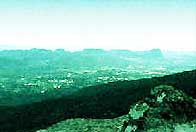
Phu Ruea is crowned with many varieties of fertile forests, such
as dense forest with many kinds of trees, hardwood forest, and
primeval forest. Many animals can be found, especially birds
migrating from China to this Park in winter. The plateau atop
the peak is covered with coniferous woodland alternating with
rock gardens and rock terrain, which are nourished by perennial
creeks.
The climate in Phu Ruea is temperate all year long. Tourists can
admire the sea of fog from various viewpoints along the cliff.
Frost can happen from time to time.
The Park offers tents and 4 houses, which can houses 5 persons
each, for tourists.
Those interested can ask for more information and reserve more
information and reserve accommodation at the Forestry
Department, Khet Chatuchak Bangkok 10900.
Route to Phu Ruea summit Decho Viewpoint
This sunrise viewpoint reveals many of Loei’s mountains on clear
days.
Pha Sam Thong
|
Another viewpoint on the route to Pha Lon Noi, this
steep cliff is adorned with gold lichen.
|
|
Pha Lon
Noi
Very beautiful sunrise viewpoint at the altitude of about 1,320
meters above sea level, Pha Lon noi overlooks Phu Luang, Phu Pha
Sat, Phu Khrang and a sea of mountains. It is the end of the
highway to Phu Ruea. Visitors must park here and walk for about
700 meters to its top.
Phu Ruea Summit
At an altitude of 1,365 meters from sea level, the highest peak
in the Park is covered with rocky terrain, alternating with
grassland, and natural and man-made coniferous forests. On clear
days the Hueang and Mekong Rivers which demarcate the
Thai-Laotian border can be seen from this viewpoint.
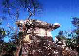
Phali Rock Garden
|
|
This large rock
garden has many exotic-shaped rocks, formed by the erosion
of sand stones commonly found in the northeastern region. |
Huai Phai Waterfall
|
The steep, one-leveled, 30 meters high waterfall is
accessibly by foot.
|
|
Suan Hin Pha Ngam
Located in King Amphoe Nong Hin, about 55 kilometers from Amphoe
Phu Kradueang, this place is always compared to the world-famous
Guilin in China. The terrain is adorned with scattering big and
small mountains of exotic shapes, some of which allow passers-by
to walk through.
|