Khon Kaen
boasts of a lengthy history and has been the birthplace of
so many thriving civilizations and cultures. This is an
area where the first dinosaur fossils were found in
Thailand. Once the quiet capital of one of the poorest
provinces in the Northeast, it has undergone dramatic
changes and is now a prosperous, bustling town. Located
at the heart of the region, it is the focal point of
many regional development projects, including the site
of the region’s largest public university, commerce
activities and abounds with beautiful, natural
surroundings.
Khon Kaen is 445 kilometres
from Bangkok and has an area of about 10,886 square
kilometres. It comprises the districts of Muang, Ban
Phai, Phon, Nam Phong, Chum Phae, Phu Wiang, Mancha
Khiri, Nong Ruea, Kranuan, Nong Song Hong, Chonnabot, Si
Chomphu, Waeng Noi, Ubolratana, Ban Fang, Khao Suan
Kwang, Phra Yuen, Waeng Yai, Pueai Noi, Phu Pha Man,
Khok Pho Chai, Nong Na Kham, Sam Sung and Ban
Haet.
Art and Cultural Centre
Art and Cultural Centre Located
in the compound of Khon Kaen University, the Isan
barn-style building features local knowledge in
different areas; namely, arts, geography and history
through a modern display. The centre can be accessed
through the Si Than Gate.
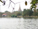
Bueng Kaen Nakhon
Bueng Kaen
Nakhonhas a large area of around 600 acres. It is
the rest and exercise spot of city people.
It is at its most beautiful at sunset. A
road circling the lake is lined with
numerous restaurants. The northern end of
the lake is the Chao Phia Mueang Phaen
monument
that was built to honour Khon Kaen’s founder.
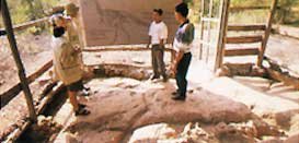
Hong Mun Mang or Khon Kaen City Museum
This museum is situated
by the Kaen Nakhon Lake in the town.
Hong:
means a tower for keeping treasures. Hong Mun Mang is
a tower where accumulated historical articles of
Khon Kaen are preserved. It is a museum which
reflects the way of life of Khon Kaen people from
the past to the present.
This museum was
established in order to link each community in Khon
Kaen province and to make people feel pride in their
community. It is also a center of study and research
on the history of Khon Kaen. There are 5 zones:
Zone 1 : Introduction to
Khon Kaen province
Zone 2 : History and Culture of Khon Kaen
Zone 3 : The founding of the city
Zone 4 : Towns and lifestyles of Khon Kaen people
Zone 5 : Khon Kaen Today.
The museum is open
daily, except Mondays, from 12 noon - 8.00 p.m.
Entrance fee is 90 baht. For more information
please contact The Town Council Office of Khon Kaen,
Prachasamran Road, Mueang District, Khon Kaen
Province, Tel.0 4327 1173, 04322 4032
during office hours.
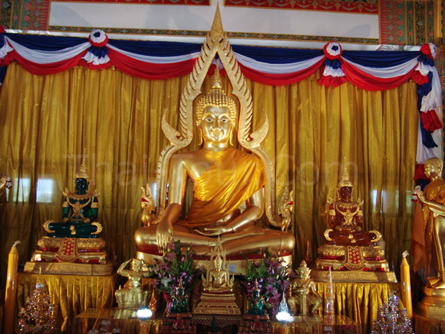
Khon Kaen National Museum
Khon Kaen
National Museum Located on Lang Sun
Ratchakan Road, the museum exhibits antiques
and precious art pieces from pre-historical
to historical periods as well as a skeleton
of the New Stone Age man and tools found at
Ban Chiang.
Visitors should not miss to see sandstone
Sema boundary markers from the Semas
Dvaravati period. The boundary markers were
carved delicately featuring the life of the
Lord Buddha. These were discovered at Fa
Daet Song Yang ancient city in Kalasin
province.
Other interesting exhibits include stone
lintels from Khmer ruins in the region as
well as art pieces from other periods
namely, Sukhothai and Ayutthaya, and native
tools. These exhibits well facilitate study
in history, archaeology and the lifestyle of
Isan. The museum is open daily from 9.00 am.
to 4.00 pm. Admission fee is 30 baht. For
more information, call Tel. 0 4324 6170.
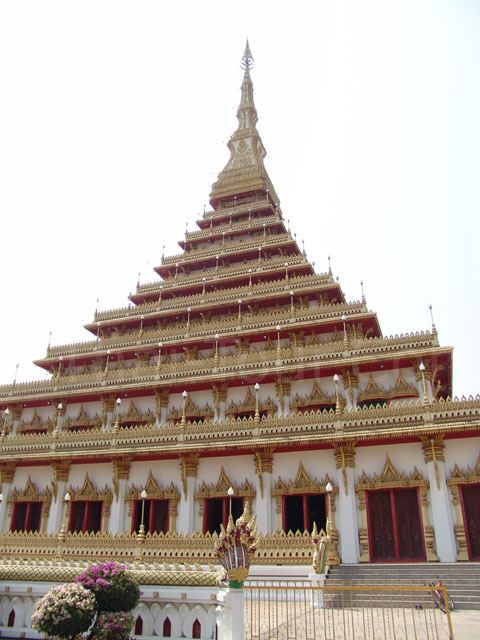
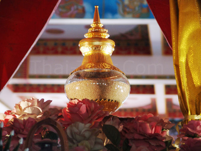
Phra Mahathat Kaen Nakhon
Phra Mahathat Kaen Nakhon or The
9-storey stupa Located in Wat Nong
Waeng, a royal temple on Klang Mueang Road, the Phra
Mahathat houses relics of the Lord Buddha and
important Buddhist scriptures. Doors and
windows of the 9 storeys of the stupa are
beautifully carved, featuring the life and former
reinearnations of the Lord Buddha, 16 classes
of visible deities in the Brahma’s world, and
Buddhist rites. Murals within the stupa feature
history of the town. The top floor, on the 9th
storey, houses relics of the Lord Buddha. Visitors
can enjoy a panoramic view of the town from there.
Chonnabot
Sala Mai Thai
Sala Mai Thai
Located in Khon Kaen Vocational College, Sala Mai
Thai is part of the project to celebrate the 60th
birtday anniversary of Her Majesty the Queen (August
12, 1992). The silk centre was established to
support Her Majesty the Queen’s mission to promote
silk and silk products from Isan as well as conserve
the traditions. The centre feature the silk
production process from dyeing to weaving, tools for
silk production and rare equipment, and different
ancient silk textiles various pattern. The centre
also exhibits the world’s most expensive Mudmee silk
textile woven by the people of Chonnabot people. The
silk textile has won Asian award in silk contest.
Sala Mai Thai is open daily during
official hours, Monday to Friday during 8.30 a.m. to
4.30 p.m. For more information, contact the Khon
Kaen Vocational College, Amphoe Chonnabot, Khon Kaen
40180 at Tel. 0 4328 6160.
How to get there:.
From downtown Khon Kaen, visitors can go via Highway 2
(Khon Kaen-Korat) for 44 kilometres. Turn right at
Ban Phai Intersection to Highway 229 and go for
another 11 kilometres. Sala Mai Thai is on the left,
opposite to Kong Kaeo Lake.
Chum Phae
Non Mueang Ancient Town
Non Mueang Ancient Town
The ancient town is located at Ban Na Pho,
80 kilometres from downtown Khon Kaen.
Legends say the hill known as Non Mueange
was the location of an ancient town.
Acquiring a 216 rai area, the oval hill has
double moats. Archaeologists have found
sandstone Sema boundary markers in Dvaravati
style in the town and nearby. Potsherds were
scattered around. Some were painted in red,
and some decorated with incising and
cord-marked patterns.
In the soil layer of the Dvaravati period
(7-11th century), none of the
funeral-related artifacts was found. So,
archaeologists presumed that the funeral of
this town changed after the arrival of
Buddhism. In deeper soil, more interesting
historical evidence was found.
Archaeologists found that
there used to be a human settlement here
since the late pre historic period. They
discovered human skeletons dating back
2,500 years ago. Funeral tools and utensils
were buried together with the bodies. The
utensils found included pottery decorated
with painted , incising and cord-marked
pattern, bronze and animal-bone bangles,
shells, colorful beads, as well as iron
tools such as hoe, sickle, and animals’
bones; namely deer, barking deer, and
different fishes. These artifacts prove that
people in this community lived on
agriculture until the Lop Buri period
(11-12th century).
How to get there: Motorists can get there
via Highway 12, Khon Kaen-Chum Phae Road,
then make a left turn at Chum Phae Post
Office, continuing for another 5 kilometres.
.
Tham Pha Phuang Forest Park
Tham Pha Phuang Forest
Park is in Ban Dong Lan, Tambon Pha Nok Khao, 123
kilometres from Khon Kaen on the Khon Kaen-Chum Phae
road by Highway No. 12 and 201. A 4-kilometre road
on the right then takes you to the park. Tham Pha
Phuang is a huge limestone cave. Inside is a large
chimney-shaped rock and lovely stalagmites and
stalactites.
Nam Phong
Ban Khok Sanga king cobras village
King
Cobras Village Ban Khok Sa-nga in
Tambon Sai Mun is famous for its strange
pets, king cobra, kept at every house. The
villagers formally earned extra income by
selling herbal medicines by travelling
around through viillages. By 1951, a local
doctor, Ken Yongla initiated a cobra show,
which was successful to attract clients to
the village. Anyway, a cobra show was too
dangerous as the snake can spit its poison
for two metres making a man blind. So he
changed to conduct the show with a king
cobra and inherited such skill to the
villagers.
Today, after the harvest season, with better
transportation, villagers of Khok Sa-nga
always travel around to organise a snake
show and offer their herbal medicine. In the
village, a snake show is held at Wat Si
Thamma, performing different series of show
such as snake dancing and boxing between
king cobra and man. Exhibitions regarding
the king cobra as well as nursery are
located nearby.
How to get there: Ban Khok Sa-nga is 49
kilometres from downtown Khon Kaen. Visitors
can go via Highway 2 and make a right turn
at kilometre 33 to Highway 2039. At
kilometre 14, opposite Phang Thui police
box, turn right onto a soil road. Then keep
going through Ban Na Ngam and make a left
turn at the intersection, continue for
another 600 metres.
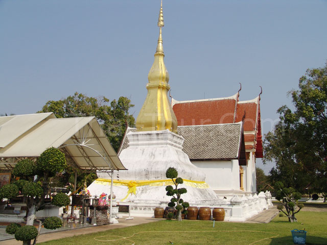
Phrathat Kham Kaen
Phrathat
Kham Kaen Located in Wat Chetiyaphum,
the Phrathat is believed to be the origin of
Khon Kaen city since ancient times. Phrathat
Kham Kaen can be date the 20th century A.D.
According to legend ,a back to king
who ruled Mori town in the Khmer kingdom
assigned 9 senior monks to bring relics of
the Lord Buddha to be placed in Phrathat
Phanom. On the way, the caravan spent a
night here, setting a camp by the heartwood
of a dead tamarind tree. The caravan reached
Nakhon Phanom on the next day just to
learn that Phrathat Phanom had already been
completed, so they returned on the same
route with a wish to place the relics at
their hometown instead. On the way back,
they were surprised to find the dead
tamarind tree buddingly lush. Therefore,
they decided to build a Phrathat here
and placed the relics and Buddha images
inside, naming Phrathat Kham Kaen which
means the stupa of tamarind heartwood.
The Phrathat is now well renovated and
landscaped. A celebration is held annually
on the full moon day of the 6th lunar month.
Phrathat Kham Kaen is 12 kilometres from
downtown Khon Kaen. Visitors can get there
via Highway 209 (Khon Kaen-Kalasin route).
After crossing the Nam Phong River, turn
left and keep going for another 14
kilometres.
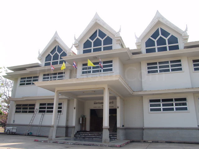
Prem Tinsulanonda Military Fort and Hall of Honour
Prem Tinsulanonda Military Fort and
Hall of Honour The hall of honour features the
biography and achievement of statesman Gen. Prem
Tinsulanonda who devoted himself for developing
Thailand in different areas. Group visitors can
contact in prior at the Prem Tinsulanonda Fort, Tel.
0 4324 9490.
Ban Phai
Scientific Centre for Education, Khon Kaen Province
Scientific Centre for Education, Khon
Kaen Province Located on a 51 rai
plot of land, the centre is a knowledge hub in
science and technology for children, youth,
students, and the public. The 2-storey building has
various exhibitions regarding science and
environment as well as the Scientist Princess Room
which features history and performances of Prof. Dr.
Princess Chulabhorn and the Primeval World Room
which features dinosaur and fossils.
The scientific center is open on weekdays from 8.30
am. to 4.30 pm. Call 0 4327 4154 for more
information.
Ban Fang
Hat Sawan
Hat Sawan
Acquiring a 62 rai area, the scenic beach by the
lake over Ubolratana Dam is an ideal place for
recreation among the locals and tourists.
Phra That Kham Kaen
Phra That Kham Kaen is
in Wat Chetiyaphum, Tambon Ban Kham. It can be
reached by driving for 16 kilometres on Highway No.
209 (Khon Kaen-Kalasin road) and going left for 14
more kilometres. This is Khon Kaen’s main historical
site. Legend has it that a dead tamarind stump
miraculously grew branches and leaves again after a
procession bearing the holy relics of Lord Buddha
walked past. A pagoda was then built the area, and
the name of the province was actually derived from
this sacred place.
Pueai Noi
Prasat Pueai Noi
Prasat Pueai Noi is the
largest Khmer sanctuary in the upper Northeast. The
compound comprises 3 brick buildings built on the
same laterite base. All face to the east. Each
pagoda has a sandstone lintel with designs. Each
pagoda has a smaller chapel and a lintel with clear,
lovely designs. A laterite wall surrounds the
compound and there is a pool just beyond it. From
Khon Kaen, take Highway No. 2 for 44 kilometres to
Ban Phai, then take Highway No. 23 for 11 kilometres
to Borabu district, then take a right-hand road for
24 kilometres to Ku Pueai Noi.
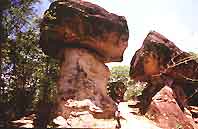
Phu Pha
Man
Phu Pha Man
National Park
Phu Pha Man National Park
The obvious natural landmark of this park is
the towering limestone cliff that looks like
a huge curtain. Lush jungle and mixed forest
keep this place cool almost all the year
round. Acquiring a total area of 218,750
rai, the park covers areas in Amphoe Phu Pha
Man and Amphoe Chum Phae of Khon Kaen as
well as Amphoe Phu Kradueng of Loei.
Attractions in this national park are rather
scattered; therefore, travel routes can be
divided into two routes.
Amphoe Phu Pha Man route – From Highway 12
(Chum Phae-Phetchabun) travel along Highway
201 and continue for another 10 kilometres
before turning left to Amphoe Phu Pha Man.
Tham KlangKhao The cave is in Phu
Pha Man Mountain, 2.5 kilometres from Amphoe Phu
Pha Man. The cave’s entrance is some 100 metres
above ground level. Inside is the habitat of
millions of bats, whose accumulated droppings
cause a strong smell.
Every evening, around 6 pm., these bats always
leave the cave in line, over ten kilometres
long. It takes some 30-45 minutes until the last
bat leaves the cave.
Tham Phra Near to Tham
Klangkhao, this cave has a natural tunnel
sloping up to the crest of Phu Pha Man, but it
is quite difficult to get through. The cave
houses beautiful stalagmites, stalactites, and
big stone pillars. The cave entrance can be
accessed by car in any season. Winter, from
November to February, is the best period to
visit the cave.
Tham Pu Ta Lo The cave is
in Ban Wang Sawap, 17 kilometres from downtown
Amphoe Phu Pha Man. Cars can access to the cave
entrance only in the dry season, from November
to April. The cave has a spacious chamber,
covering over a one rai area. With flat soil
ground and 5-7 metre high ceiling, good
ventilation allows visitors to enjoy admiring
the cave comfortably. Stalagmites and
stalactites remain untouched. Some glittering
stones look like rock crystals.
Namtok Tat Fa Tat Fa creek,
natural borderline between Amphoe Phu Pha Man of
Khon Kaen and Amphoe Nam Nao of Phetchabun,
cascades through five steps to form this
waterfall. The last step is the most impressive
one with a height of 80 metres. The rainy
season, from late May to early October is the
best period to visit the waterfall. Namtok Tat
Fa is in Ban Dong Sakhran, Mu 7 Tambon Wang
Sawap, some 40 kilometres from downtown Amphoe
Phu Pha Man. Cars can reach Ban Tat Fa, then
visitors have to trek to the waterfall.The
headquarters route-From the former route, going
through Highway 201.
Namtok Tat Yai The big waterfall
originate from Tat Fa Creek. The creek cascades
through small waterfalls before going through a
big cliff at 80 metres high. Namtok Tat Yai is
the highest waterfall in the park.
Namtok Tat Rong With a height of 60-70
metres, the waterfall originates from Phong
River that runs from Phu Kradueng. The waterfall
borders Phu Kradueng National Park and Phu Pha
Man National Park. A folk tale says the
waterfall can sing as water runs upon a piece of
thin stone, the falling water veers off into
different rock holes nearby and fills the forest
with strange sounds.
Tham Phaya Nakharat As winding as a
giant naga, the one-kilometre long cave is
naturally decorated with glittering curtain-like
stalagmites and stalactites. Cars can access to
the cave entrance.
Tham Lai Thaeng Some 800 metres from
Tham Phaya Nakharat is tham Lai Thaeng whose
wall has ancient paintings on some two-square
metre area. The paintings contain some 70
pictures of humans, animals, and others,
mirroring culture and life in the pre-historical
period dating back to over 2,000 years ago.
The national park has not any accommodation and
facility for tourists. Visitors should prepare
everything by themselves. For more information,
please contact the Department of National Park,
Wildlife and Plant Conservation Department at
Tel. 0 2562 0760.
www.dnp.go.th
Tham Pu Lup The cave is on Highway 201. Its
five chambers are all decorated with glittering
stalagmites and stalactites. The cave contains
water the year round.
Pha Nok Khao The towering cliff of black
rock by the Phong River looks like an owl or Nok
khao in Thai. It is 125 kilometres from downtown
Khon Kaen. Tourists can get there via Highway 2
and 201 (Khon Kaen-Wang Saphung). Pha Nok Khao
is on the left of Ban Dong Lan. The best
location to see the owl-shape cliff is at the
orchid nursery of the Forestry Department on the
other side of the road. There is another nearby
place of interest known as Namtok Tat Ron, or
Namtok Tat Hong as it is called by local
dialect name. The 70-matre high waterfall is
located in neighboring Loei province on the
boundary of Phu kradueng national Park, Phu Pha
Man National Park and the Phong River. The sound
made by the waterfall when cascading onto a huge
a large stone slab beneath is how the waterfall
derived its name.
Phu Wiang
Buffalo Conservation Village
Buffalo Conservation Village
Supported by the provincial livestock offices,
villagers have kept lots of water buffaloes until
the village was honoured as the centre to conserve
and develop Thai water buffalo. For more
information, call Nawa Subdistrict Administration
Organisation at Tel. 0 4321 1466.
Pattaya II
Pattaya II The pond
acquiring an area of 20 rai is at Ban Nong Kung
Soen, 78 kilometres from Amphoe Mueang. The scenic
pond with the backdrop of Phu Phan Mountain is a
nice place where the locals love to relax. Besides
delicious freshwater fish cuisine available around
the pond, there are various water sports tourists
can enjoy.
How to get there: from Amphoe Mueang, tourists can get
there via Highway 12 and turn right on Highway 2038,
continue for another 12 kilometres then turn right
onto Kiatsuranond Road. Go for another 12
kilometres, then turn left to Ban Kho. Turn another
left at Wat sopha Rattana Phatthanaram, go ahead and
make a right turn.
Phu Wiang
National Park
Phu Wiang National Park This national
park always reminds tourists about dinosaurs.
Indeed, nobody had formerly ever though the Isan
plateau was once home of dinosaurs. Until 1976
when a uranium survey team discovered a piece of
fossil, which was examined by French specialists
and declared that it was a left knee bone of a
dinosaur. After that, serious execration has
never ended until now.On the hill Pratu Ti Ma,
which was the first site,geologists have found
fossils of a dinosaur,15 metres high with a long
neck and tail.
This is a kind of
plant-eating dinosaur never found else where before,
so it was named Phuwiangosaurus Sirindhornae to
honour H.R.H Princess Maha Chakri Sirindhorn. In
this site, over ten teeth of a meat-eating dinosaur
have also been found. So geologists’ scientists
presumed that the long-necked dinosaur was prey for
these teeth’s owner. Among these teeth, one is
different. After a study, scientist found that it
belonged to a new species of dinosaur never found
before. So it was named ‘Siamosaurus Suteethorni’
after the discoverer, Mr. Warawuth Suteethorn.
All the three sites are not far from the headquarters,
and tourists can also visit the second and third
sites nearby.Fossils of Siamotyrannus Isanensis
found here are the oldest one, dating back 120-130
million years. This indicates that
tyrannosaurus originated in Asia. These fossils are
now displayed in the museum of the Department of
Mineral Resources.
At the 8th site, there are 68 footprints of
dinosaurs, dating back 140 million years ago.
Most of them belong to the world’s smallest species
of meat-eating dinosaur, which walked on two legs.
Among such footprints, there is one bigger
footprint, assumed to belong to Carnosaurus.
These sites are 19 kilometres from the headquarters.
It takes an hour to get there by car and four-wheel
drive vehicle is recommended. In many sites,
geologists found fossils of dinosaur babies, small
crocodiles and mussels dating back to 150 million
years ago.
Besides fossils of dinosaurs, there are also traces
of ancient civilizations in this area including a
high relief of the reclining Buddha on the cliff, at
the crest of Phu Wiang Mountain. The Buddha image
was carved in the 9th century, mirroring an
influence from Indian art. Nearby is Tham Famue
Daeng, Dang, or Red Palm Cave, at Ban Hin Rong. The
cave wall houses prehistoric paintings of cave men’s
hands from sprays of red ochre.
Natural attractions in the park include waterfalls
and field of wild flowers. Namtok Thap phaya Suea is
a small waterfall near to Tham Famue Daeang. Namtok
Tat Fa is a 15-metre high waterfall that can be
accessed by car. The waterfall is 18 kilometres from
Amphoe Phu Wiang. Some 5 kilometres from Namtok Tat
Fa is Namtok Tat Klang which is a 8-metre high
waterfall. Savanna and rock plateaus are always
blanketed with wild flowers in full bloom by the end
of the rainy season.
Phu Wiang National Park acquires a total area of 380
square kilometres in Amphoe Si Chomphu and Amphoe
Chum Phae.
How to get there: from downtown Khon Kaen, visitors
can get there via Highway 12 and connect to Highway
2038, bound for Amphoe Phu Wiang. From Amphoe Phu
Wiang, talk the Phu Wiang-Ban Muaeng Mai Road,
passing the national park unit, Pak Chong Phu Wiang’
at kilometre 23. Turn left at kilometre 30 at Ban
Pho Reservoir and the national park’s headquarters
is 8 kilometres away. The headquarters features an
exhibition about the dinosaurs and fossils found in
the area. For group tourists requiring a guide,
contact the headquarters in advance at Tel. 0 4324
9052.
Mancha
Khiri
Chang Kra
Chang Kra Having
grown wild over a century ago in Wat Pa Mancha Khiri
over 4,000 Chang Kra orchid-Rhyncostylis gigantean
(Lindl.) Ridl.-are in full bloom on the branches of
some 280 trees every year during January and
February. These wild orchids always fill the whole
area with their mild fragrance.
How to get there: the
temple is only a kilometre from downtown Amphoe
Mancha Khiri, 57 kilometres from downtown Khon Kaen.
From Bangkok, motorists can drive via Highway 2
(Mitraphap Road) then turn left to Amphoe Chonnabot,
via Highway 229 (Chonnabot-Mancha Khiri). The
entrance to the temple is on the left before
reaching Amphoe Mancha Khiri or some 35 kilometres
from Mitraphap Road. From Khon Kaen, motorists can
go via Highway 2731 and 2062 through Amphoe Phra
Yuen.
Sim (ubosot of Wat Sa Thong Ban Bua )
Sim (ubosot of Wat Sa Thong Ban Bua )
This Sim, ordination hall, is architectural heritage
of Isan with outstanding local characters. The
exterior is decorated with colourful mural and
glass. The Sim houses a rare Isan-style sandstone
Buddha image. In 2002, the Sim was awarded a
precious architecture, heritage and cultural
conservation of the Asia Pacific by UNESCO.
Tortoise Village
Tortoise Village The
villagers keep a large amount of tortoises
as their mutual pets. The brownish yellow
shelled tortoises, called Tao Phek in local
dialect, always travel around in the village
to be fed.
How to get there: from downtown Khon Kaen,
motorists can drive via Highway 12( Khon
Kaen –Chum Phae) for ten kilometres then
turn left to Highway 2062 (Khon Kaen-Mancha
Khiri) for another 54 kilometres. The
entrance to the tortoise village is on the
left at Ban Kok, two kilometres prior to
Amphoe Mancha Khiri. It is easy to notice
with two tortoise replicas on the roadside
opposite to Wat Si Sumang. Turn left through
Ban Kok, the tortoise village is 50 metres
away.
Nong Ruea
Nam Phong National Park
Nam Phong National Park
acquiring a total area of 197 square kilometres, the
park covers a large area in Khon Kaen namely; Nong
Ruea, Ubolratana, Phu Wiang, Ban Fang, Mancha Khiri,
and Khok Pho Chai as well as two Amphoes in
Chaiyaphum province, Ban Thaen and Kaeng Khro. The
park headquarters is located by the lake over
Ubolratana Dam. Forest in this national park is
watershed of the chi and Phong Rivers. The
deciduous dipterocarp and dry everygreen forests in
this mountain range are a major source of herbs.
There are viewpoints in the park. ‘Hin Chang Si’ is
a group of rocks, where wild elephants use for
scratching their flanks. This point has a scenic
view of the Uboltatana lake and Khon Kaen city. Hin
Chang Si viewpoint can be accessed by car, eight
kilometres from Sok Tae Reforestation Park. From the
head quarters, walking to Hin Chang Si takes around
two hours. Some 30 minutes on foot from Hin Chang Si
is Plan Chat viewpoint. Pha Sawan is another
viewpoint from where visitors can witness beautiful
scenery of the lake. The cliff is a two-hour walk
from the headquarters. Another interesting
attraction in the park is Phon Kham, crater-like
rock well. For more information, call Nam Phong
National Park at Tel. 0 4324 8006 or of National
Park, Wildlife and Plant Conservation Department in
Bangkok at Tel. 0 2562 0760.
How to get there: Nam Phong National Park can be
reached from two routes.
1. From Khon Kaen, go via Highway 12 to Chum Phae
District, then turn right at kilometre 30 to Ban
PHue for another 19 kilometres via Highway 3034
(Nong Saeng-Tha Ruea). This route is 49 kilometres.
2. From Khon Kaen, bound for Amphoe Ubolratana via
Highway 2, heading for Udon Thani, then turn left to
Amphoe Ubolratana. In the Amphoe, use Highway 3034,
which lies along the lake over Ubolratana Dam. This
route is 65 kilometres long.
Nong
Song Hong
Wat Sa Bua Kaeo
Wat Sa Bua Kaeo The temple
is located at Ban Wang Khun. The mural and
sculptural works of this temple is worth a visit.
Crouching guardian lion replicas are on both sides
of the stairway leading up to the Ubosot, ordination
hall, with sculptures of men stretching their legs
in front in front. Luangpho Phui, preceptor of the
temple, created all of these sculptures. Murals on
four walls of this concrete ordination hall, both
exterior and interior, feature the people’s
lifestyle, history of the Lord Buddha, heaven and
hell and folklore. The pictures are separated by the
so-called Sinthao line, a flash-shape pattern which
is widely found in murals from the Ayutthaya and
Rattanakosin periods, not in the Isan region. By the
unique brushwork, the murals mirror freedom of the
artist in expressing emotion into the pictures,
trees and animals, like Western impressionists. The
favorites colors include yellow, indigo, red ochre,
green, blue and black.
How to get there: From downtown Khon Kaen, visitors
can go via Highway 2 (Mitraphap Road), heading to
Amphoe Phon for 75 kilometres, then turn left to
Highway 207 bound for Amphoe Nong Song Hong for
another 17 kilometres. At kilometre 27-28, turn
right at Ban Wang Khun and go ahead for a kilometre.
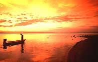
Ubolratana
Bang Saen II and Hat Chom Thong
Bang Saen II and Hat Chom Thong
the beaches are in Ban Hin Phoeng, Tambon Tha Ruea,
53 kilometres from downtown Khon Kaen. As part of
the lake over Ubolratana Dam, the beaches are quite
picturesque particularly when the sun sets behind
the mountain ranges. There are various water sports
available such as water bicycle, banana boat, and
scooter. Visitors can enjoy fish a menu of freshly
caught from the lake. During the holidays, the
beaches are always quite lively.
Phu Kao-Phu
Phan Kham National Park
Phu
Kao-Phu Phan Kham National Park The
park acquires a total area of 320 square
kilometres or 201,250 rai, in Amphoe Ubolratana
and Amphoe Non Sang of Nong Bua Lam Phu
province. Most area is deciduous dipterocarp
forest, which always changes its hue by early
November. The national park headquarters at Phu
Phan Kham by the lake has a picturesque sunset
view. Camping ground is available. The
attractions in the park include traces of a
pre-historical community of the same period as
Ban Chiang such as cave paintings and carvings
footprints of dinosaurs that are presumed to be
the same species as those found in Phu Wiang.
How to get
there: from Khon Kaen, head for Ubolratana Dam until
reaching Ubolratana Market 50 kilometres away. Then
go via the Ubolratana-Non Sang Road, the park
headquarters is 6 kilometres away. Motorists can
also reach the park through the Udon Thani-Loei
Road, then go through Amphoe Non Sang and get onto
the Sok Chan-Ubolratana Dam Road. Bus on the route
Ubolratana Dam-Non Sang also reach the park. The
buses leave from Ubolratana Market.
Ubolratana dam
Ubolratana dam is
the largest multi-purpose dam in the Northeast.
To get there, take Highway No. 2 (Khon Kaen-Udon
Thani) for 26 kilometres, turn left and drive
for 24 kilometres. The dams is across the Phong
river at the pass connecting Phu Kao and Phu
Phan mountains. The view at the dam is
magnificent. Tourists regularly frequent the
area to look at the lake and sample local
delicacies, including the famous grilled fish
famous here.
Khok
Pho Chai
Wat Udom Khongkha Khiri Khet
Wat Udom Khongkha Khiri Khet
Good for meditation practicing, the temple is
located deep in lush forest in Tambon Ban Khok.
Luangpu Phang, a Buddhist monk famous in meditation,
once lived here. Today, Buddhists come to visit the
temple and pay respect to his monument in the temple
compound.
How to get there: visitors can go via Highway 12 (Khon
Kaen-Chum Phae) for 14 kilometres then turn left to
Highway 2062 (Ban Thum-Mancha Khiri Road) for
another 44 kilometres and get on highway 229 (Mancha
Khiri-Chaiyaphum Road) for 12 kilometres and turn
right into the temple, 12 kilometres away.